You are here: Home > Network List > TA - USArray Transportable Network (new EarthScope stations) Stations List
> Station I23K Minto, Yukon-Koyukuk, AK, USA > Earthquake Result Viewer
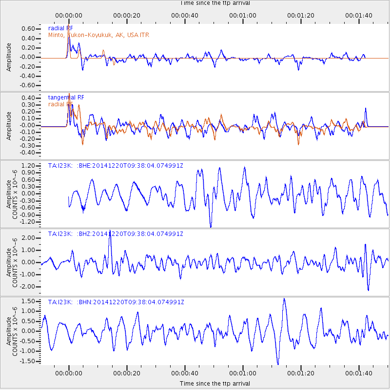
I23K Minto, Yukon-Koyukuk, AK, USA - Earthquake Result Viewer
*The percent match for this event was below the threshold and hence no stack was calculated.
| Earthquake location: |
Near East Coast Of Honshu, Japan |
| Earthquake latitude/longitude: |
37.4/141.5 |
| Earthquake time(UTC): |
2014/12/20 (354) 09:29:58 GMT |
| Earthquake Depth: |
37 km |
| Earthquake Magnitude: |
5.9 MB |
| Earthquake Catalog/Contributor: |
NEIC PDE/NEIC COMCAT |
|
| Network: |
TA USArray Transportable Network (new EarthScope stations) |
| Station: |
I23K Minto, Yukon-Koyukuk, AK, USA |
| Lat/Lon: |
65.15 N/149.36 W |
| Elevation: |
149 m |
|
| Distance: |
48.1 deg |
| Az: |
32.048 deg |
| Baz: |
269.845 deg |
| Ray Param: |
$rayparam |
*The percent match for this event was below the threshold and hence was not used in the summary stack. |
|
| Radial Match: |
52.552063 % |
| Radial Bump: |
400 |
| Transverse Match: |
60.860615 % |
| Transverse Bump: |
400 |
| SOD ConfigId: |
826720 |
| Insert Time: |
2015-01-04 02:47:36.006 +0000 |
| GWidth: |
2.5 |
| Max Bumps: |
400 |
| Tol: |
0.001 |
|
Signal To Noise
| Channel | StoN | STA | LTA |
| TA:I23K: :BHZ:20141220T09:38:04.074991Z | 2.429627 | 5.827148E-7 | 2.3983714E-7 |
| TA:I23K: :BHN:20141220T09:38:04.074991Z | 0.64981395 | 3.005424E-7 | 4.625053E-7 |
| TA:I23K: :BHE:20141220T09:38:04.074991Z | 0.80437136 | 2.759296E-7 | 3.430376E-7 |
| Arrivals |
| Ps | |
| PpPs | |
| PsPs/PpSs | |


