You are here: Home > Network List > US - United States National Seismic Network Stations List
> Station ACSO Alum Creek State Park, Ohio, USA > Earthquake Result Viewer
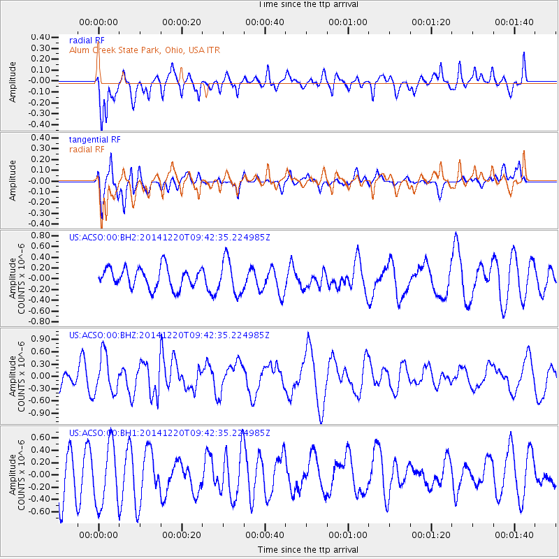
ACSO Alum Creek State Park, Ohio, USA - Earthquake Result Viewer
*The percent match for this event was below the threshold and hence no stack was calculated.
| Earthquake location: |
Near East Coast Of Honshu, Japan |
| Earthquake latitude/longitude: |
37.4/141.5 |
| Earthquake time(UTC): |
2014/12/20 (354) 09:29:58 GMT |
| Earthquake Depth: |
37 km |
| Earthquake Magnitude: |
5.9 MB |
| Earthquake Catalog/Contributor: |
NEIC PDE/NEIC COMCAT |
|
| Network: |
US United States National Seismic Network |
| Station: |
ACSO Alum Creek State Park, Ohio, USA |
| Lat/Lon: |
40.23 N/82.98 W |
| Elevation: |
288 m |
|
| Distance: |
92.6 deg |
| Az: |
32.509 deg |
| Baz: |
326.007 deg |
| Ray Param: |
$rayparam |
*The percent match for this event was below the threshold and hence was not used in the summary stack. |
|
| Radial Match: |
66.09744 % |
| Radial Bump: |
400 |
| Transverse Match: |
72.57141 % |
| Transverse Bump: |
400 |
| SOD ConfigId: |
826720 |
| Insert Time: |
2015-01-04 02:48:15.360 +0000 |
| GWidth: |
2.5 |
| Max Bumps: |
400 |
| Tol: |
0.001 |
|
Signal To Noise
| Channel | StoN | STA | LTA |
| US:ACSO:00:BHZ:20141220T09:42:35.224985Z | 1.8904574 | 4.6548251E-7 | 2.4622747E-7 |
| US:ACSO:00:BH1:20141220T09:42:35.224985Z | 1.3046811 | 5.074688E-7 | 3.8896005E-7 |
| US:ACSO:00:BH2:20141220T09:42:35.224985Z | 1.7512383 | 3.2790808E-7 | 1.8724354E-7 |
| Arrivals |
| Ps | |
| PpPs | |
| PsPs/PpSs | |


