You are here: Home > Network List > US - United States National Seismic Network Stations List
> Station AMTX Amarillo, Texas, USA > Earthquake Result Viewer
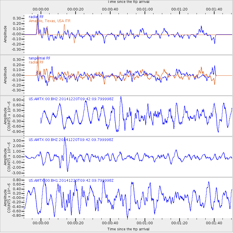
AMTX Amarillo, Texas, USA - Earthquake Result Viewer
*The percent match for this event was below the threshold and hence no stack was calculated.
| Earthquake location: |
Near East Coast Of Honshu, Japan |
| Earthquake latitude/longitude: |
37.4/141.5 |
| Earthquake time(UTC): |
2014/12/20 (354) 09:29:58 GMT |
| Earthquake Depth: |
37 km |
| Earthquake Magnitude: |
5.9 MB |
| Earthquake Catalog/Contributor: |
NEIC PDE/NEIC COMCAT |
|
| Network: |
US United States National Seismic Network |
| Station: |
AMTX Amarillo, Texas, USA |
| Lat/Lon: |
34.53 N/101.41 W |
| Elevation: |
1010 m |
|
| Distance: |
87.6 deg |
| Az: |
47.391 deg |
| Baz: |
314.768 deg |
| Ray Param: |
$rayparam |
*The percent match for this event was below the threshold and hence was not used in the summary stack. |
|
| Radial Match: |
53.042377 % |
| Radial Bump: |
400 |
| Transverse Match: |
50.480522 % |
| Transverse Bump: |
400 |
| SOD ConfigId: |
826720 |
| Insert Time: |
2015-01-04 02:48:25.149 +0000 |
| GWidth: |
2.5 |
| Max Bumps: |
400 |
| Tol: |
0.001 |
|
Signal To Noise
| Channel | StoN | STA | LTA |
| US:AMTX:00:BHZ:20141220T09:42:09.799998Z | 5.5930014 | 8.2862306E-7 | 1.4815356E-7 |
| US:AMTX:00:BH1:20141220T09:42:09.799998Z | 1.4582723 | 5.0617047E-7 | 3.4710285E-7 |
| US:AMTX:00:BH2:20141220T09:42:09.799998Z | 1.0300287 | 3.7659896E-7 | 3.6561985E-7 |
| Arrivals |
| Ps | |
| PpPs | |
| PsPs/PpSs | |


