You are here: Home > Network List > US - United States National Seismic Network Stations List
> Station GLMI Grayling, Michigan, USA > Earthquake Result Viewer
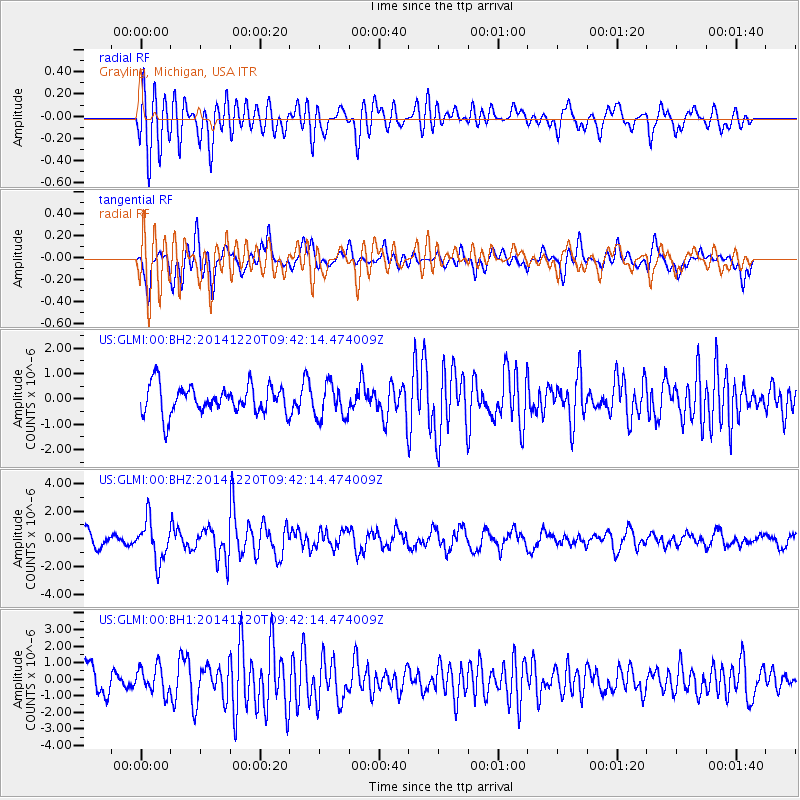
GLMI Grayling, Michigan, USA - Earthquake Result Viewer
*The percent match for this event was below the threshold and hence no stack was calculated.
| Earthquake location: |
Near East Coast Of Honshu, Japan |
| Earthquake latitude/longitude: |
37.4/141.5 |
| Earthquake time(UTC): |
2014/12/20 (354) 09:29:58 GMT |
| Earthquake Depth: |
37 km |
| Earthquake Magnitude: |
5.9 MB |
| Earthquake Catalog/Contributor: |
NEIC PDE/NEIC COMCAT |
|
| Network: |
US United States National Seismic Network |
| Station: |
GLMI Grayling, Michigan, USA |
| Lat/Lon: |
44.82 N/84.62 W |
| Elevation: |
387 m |
|
| Distance: |
88.1 deg |
| Az: |
30.904 deg |
| Baz: |
324.916 deg |
| Ray Param: |
$rayparam |
*The percent match for this event was below the threshold and hence was not used in the summary stack. |
|
| Radial Match: |
70.83386 % |
| Radial Bump: |
400 |
| Transverse Match: |
67.74871 % |
| Transverse Bump: |
400 |
| SOD ConfigId: |
826720 |
| Insert Time: |
2015-01-04 02:49:15.625 +0000 |
| GWidth: |
2.5 |
| Max Bumps: |
400 |
| Tol: |
0.001 |
|
Signal To Noise
| Channel | StoN | STA | LTA |
| US:GLMI:00:BHZ:20141220T09:42:14.474009Z | 3.7065542 | 1.465255E-6 | 3.953146E-7 |
| US:GLMI:00:BH1:20141220T09:42:14.474009Z | 1.147381 | 8.031578E-7 | 6.9999226E-7 |
| US:GLMI:00:BH2:20141220T09:42:14.474009Z | 1.1999191 | 6.6508244E-7 | 5.5427273E-7 |
| Arrivals |
| Ps | |
| PpPs | |
| PsPs/PpSs | |


