You are here: Home > Network List > AU - Australian Seismological Centre Stations List
> Station KMBL Kambalda, Western Australia > Earthquake Result Viewer
KMBL Kambalda, Western Australia - Earthquake Result Viewer
| Earthquake location: |
Northern Molucca Sea |
| Earthquake latitude/longitude: |
2.1/126.7 |
| Earthquake time(UTC): |
2014/12/21 (355) 11:34:13 GMT |
| Earthquake Depth: |
41 km |
| Earthquake Magnitude: |
6.3 MWW, 6.3 MWB, 6.4 MWC, 6.6 MI |
| Earthquake Catalog/Contributor: |
NEIC PDE/NEIC COMCAT |
|
| Network: |
AU Australian Seismological Centre |
| Station: |
KMBL Kambalda, Western Australia |
| Lat/Lon: |
31.37 S/121.88 E |
| Elevation: |
370 m |
|
| Distance: |
33.6 deg |
| Az: |
187.381 deg |
| Baz: |
8.631 deg |
| Ray Param: |
0.07805097 |
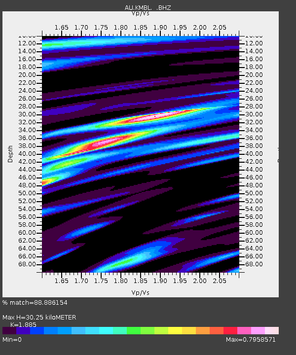
| Estimated Moho Depth: |
30.25 km |
| Estimated Crust Vp/Vs: |
1.88 |
| Assumed Crust Vp: |
6.459 km/s |
| Estimated Crust Vs: |
3.427 km/s |
| Estimated Crust Poisson's Ratio: |
0.30 |
|
| Radial Match: |
88.886154 % |
| Radial Bump: |
307 |
| Transverse Match: |
66.91091 % |
| Transverse Bump: |
400 |
| SOD ConfigId: |
827010 |
| Insert Time: |
2015-01-04 11:53:25.432 +0000 |
| GWidth: |
2.5 |
| Max Bumps: |
400 |
| Tol: |
0.001 |
|

Signal To Noise
| Channel | StoN | STA | LTA |
| AU:KMBL: :BHZ:20141221T11:40:19.769008Z | 7.6527314 | 2.7136552E-6 | 3.5459956E-7 |
| AU:KMBL: :BHN:20141221T11:40:19.769008Z | 8.359965 | 1.743027E-6 | 2.0849691E-7 |
| AU:KMBL: :BHE:20141221T11:40:19.769008Z | 0.8117174 | 2.470657E-7 | 3.0437405E-7 |
| Arrivals |
| Ps | 4.5 SECOND |
| PpPs | 13 SECOND |
| PsPs/PpSs | 17 SECOND |


