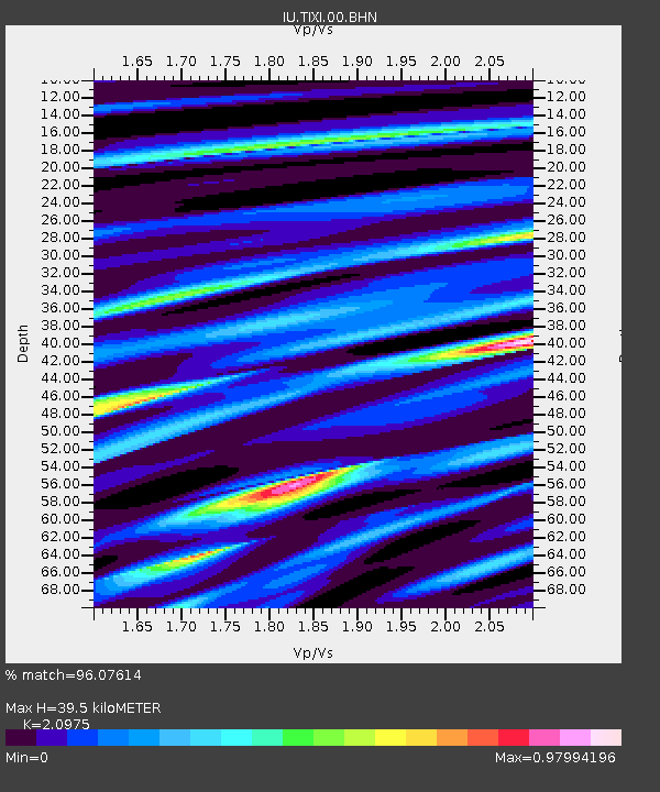
TIXI Tiksi, Russia - Earthquake Result Viewer
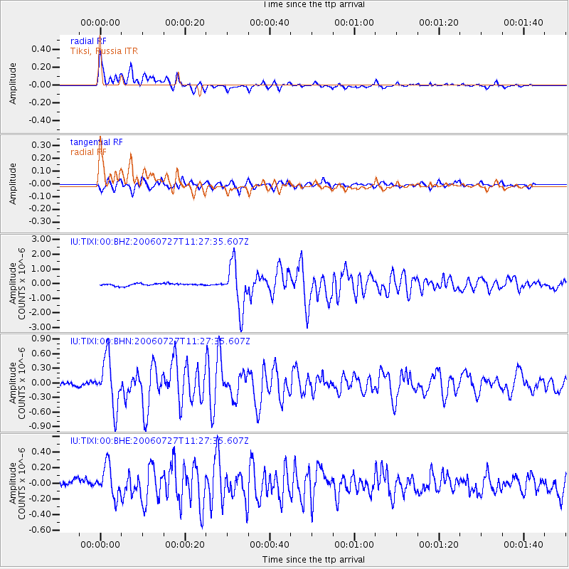
Earthquake location: Northern Sumatra, Indonesia
Earthquake latitude/longitude: 1.7/97.1
Earthquake time(UTC): 2006/07/27 (208) 11:16:40 GMT
Earthquake Depth: 20 km
Earthquake Magnitude: 5.6 MB, 6.1 MS, 6.1 MW, 6.0 MW
Earthquake Catalog/Contributor: WHDF/NEIC
Network: IU Global Seismograph Network (GSN - IRIS/USGS)
Station: TIXI Tiksi, Russia
Lat/Lon: 71.65 N/128.87 E
Elevation: 50 m
Distance: 72.7 deg
Az: 10.045 deg
Baz: 213.398 deg
Ray Param: 0.053469177
Estimated Moho Depth: 39.5 km
Estimated Crust Vp/Vs: 2.10
Assumed Crust Vp: 6.552 km/s
Estimated Crust Vs: 3.124 km/s
Estimated Crust Poisson's Ratio: 0.35
Radial Match: 96.07614 %
Radial Bump: 400
Transverse Match: 88.240265 %
Transverse Bump: 400
SOD ConfigId: 2665
Insert Time: 2010-03-02 14:53:15.480 +0000
GWidth: 2.5
Max Bumps: 400
Tol: 0.001

Signal To Noise

ChannelStoNSTALTA
IU:TIXI:00:BHN:20060727T11:27:35.607Z12.7741695.197002E-74.0683684E-8
IU:TIXI:00:BHE:20060727T11:27:35.607Z5.101372.0579769E-74.0341654E-8
IU:TIXI:00:BHZ:20060727T11:27:35.607Z20.767031.5818449E-67.617097E-8
Arrivals
Ps6.8 SECOND
PpPs18 SECOND
PsPs/PpSs25 SECOND