You are here: Home > Network List > IU - Global Seismograph Network (GSN - IRIS/USGS) Stations List
> Station KBL Kabul, Afghanistan > Earthquake Result Viewer
KBL Kabul, Afghanistan - Earthquake Result Viewer
| Earthquake location: |
Northern Molucca Sea |
| Earthquake latitude/longitude: |
2.1/126.7 |
| Earthquake time(UTC): |
2014/12/21 (355) 11:34:13 GMT |
| Earthquake Depth: |
41 km |
| Earthquake Magnitude: |
6.3 MWW, 6.3 MWB, 6.4 MWC, 6.6 MI |
| Earthquake Catalog/Contributor: |
NEIC PDE/NEIC COMCAT |
|
| Network: |
IU Global Seismograph Network (GSN - IRIS/USGS) |
| Station: |
KBL Kabul, Afghanistan |
| Lat/Lon: |
34.54 N/69.04 E |
| Elevation: |
1920 m |
|
| Distance: |
62.4 deg |
| Az: |
308.163 deg |
| Baz: |
107.857 deg |
| Ray Param: |
0.060143724 |
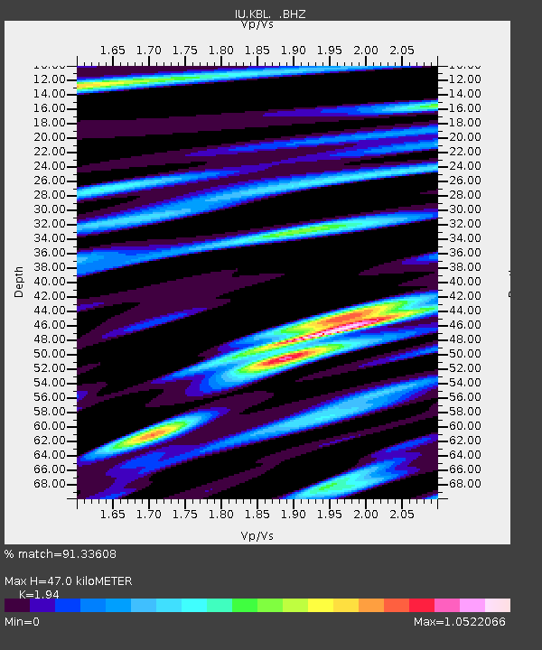
| Estimated Moho Depth: |
47.0 km |
| Estimated Crust Vp/Vs: |
1.94 |
| Assumed Crust Vp: |
6.641 km/s |
| Estimated Crust Vs: |
3.423 km/s |
| Estimated Crust Poisson's Ratio: |
0.32 |
|
| Radial Match: |
91.33608 % |
| Radial Bump: |
400 |
| Transverse Match: |
79.21844 % |
| Transverse Bump: |
400 |
| SOD ConfigId: |
827010 |
| Insert Time: |
2015-01-04 11:58:09.431 +0000 |
| GWidth: |
2.5 |
| Max Bumps: |
400 |
| Tol: |
0.001 |
|
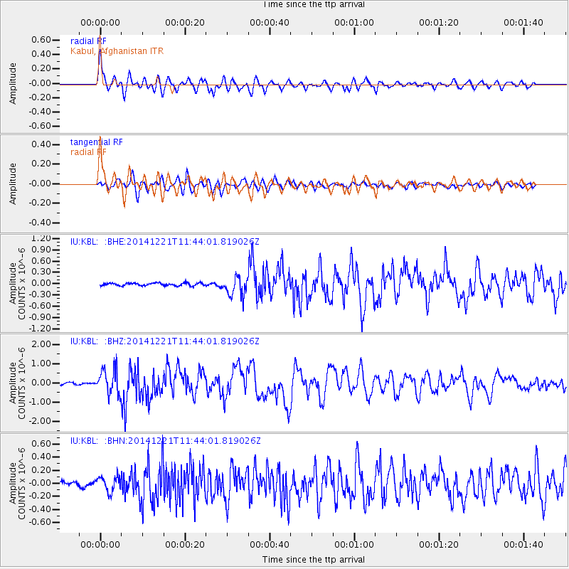
Signal To Noise
| Channel | StoN | STA | LTA |
| IU:KBL: :BHZ:20141221T11:44:01.819026Z | 14.905628 | 6.639847E-7 | 4.4545903E-8 |
| IU:KBL: :BHN:20141221T11:44:01.819026Z | 2.4871056 | 1.1584502E-7 | 4.6578247E-8 |
| IU:KBL: :BHE:20141221T11:44:01.819026Z | 7.3621182 | 2.61144E-7 | 3.5471313E-8 |
| Arrivals |
| Ps | 6.9 SECOND |
| PpPs | 20 SECOND |
| PsPs/PpSs | 27 SECOND |


