You are here: Home > Network List > KR - Kyrgyz Digital Network Stations List
> Station BOOM Boom, Kyrgyzstan > Earthquake Result Viewer
BOOM Boom, Kyrgyzstan - Earthquake Result Viewer

| Earthquake location: |
Northern Molucca Sea |
| Earthquake latitude/longitude: |
2.1/126.7 |
| Earthquake time(UTC): |
2014/12/21 (355) 11:34:13 GMT |
| Earthquake Depth: |
41 km |
| Earthquake Magnitude: |
6.3 MWW, 6.3 MWB, 6.4 MWC, 6.6 MI |
| Earthquake Catalog/Contributor: |
NEIC PDE/NEIC COMCAT |
|
| Network: |
KR Kyrgyz Digital Network |
| Station: |
BOOM Boom, Kyrgyzstan |
| Lat/Lon: |
42.49 N/75.94 E |
| Elevation: |
1737 m |
|
| Distance: |
60.5 deg |
| Az: |
318.862 deg |
| Baz: |
117.272 deg |
| Ray Param: |
0.061424043 |
| Estimated Moho Depth: |
33.0 km |
| Estimated Crust Vp/Vs: |
1.70 |
| Assumed Crust Vp: |
6.306 km/s |
| Estimated Crust Vs: |
3.704 km/s |
| Estimated Crust Poisson's Ratio: |
0.24 |
|
| Radial Match: |
91.19638 % |
| Radial Bump: |
400 |
| Transverse Match: |
85.86525 % |
| Transverse Bump: |
400 |
| SOD ConfigId: |
827010 |
| Insert Time: |
2015-01-04 12:00:14.036 +0000 |
| GWidth: |
2.5 |
| Max Bumps: |
400 |
| Tol: |
0.001 |
|
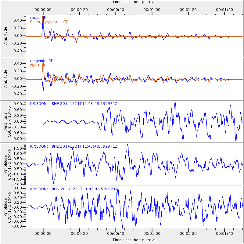
Signal To Noise
| Channel | StoN | STA | LTA |
| KR:BOOM: :BHZ:20141221T11:43:48.599971Z | 4.5509877 | 5.6297E-7 | 1.2370282E-7 |
| KR:BOOM: :BHN:20141221T11:43:48.599971Z | 1.8317798 | 1.1248997E-7 | 6.1410205E-8 |
| KR:BOOM: :BHE:20141221T11:43:48.599971Z | 4.4395466 | 2.626228E-7 | 5.915532E-8 |
| Arrivals |
| Ps | 3.9 SECOND |
| PpPs | 14 SECOND |
| PsPs/PpSs | 17 SECOND |


