You are here: Home > Network List > S - Seismographs in Schools Projects Stations List
> Station AUBSH Beerwah State High School, QLD > Earthquake Result Viewer
AUBSH Beerwah State High School, QLD - Earthquake Result Viewer
| Earthquake location: |
Northern Molucca Sea |
| Earthquake latitude/longitude: |
2.1/126.7 |
| Earthquake time(UTC): |
2014/12/21 (355) 11:34:13 GMT |
| Earthquake Depth: |
41 km |
| Earthquake Magnitude: |
6.3 MWW, 6.3 MWB, 6.4 MWC, 6.6 MI |
| Earthquake Catalog/Contributor: |
NEIC PDE/NEIC COMCAT |
|
| Network: |
S Seismographs in Schools Projects |
| Station: |
AUBSH Beerwah State High School, QLD |
| Lat/Lon: |
26.86 S/152.95 E |
| Elevation: |
26 m |
|
| Distance: |
38.4 deg |
| Az: |
140.403 deg |
| Baz: |
314.518 deg |
| Ray Param: |
0.07549333 |
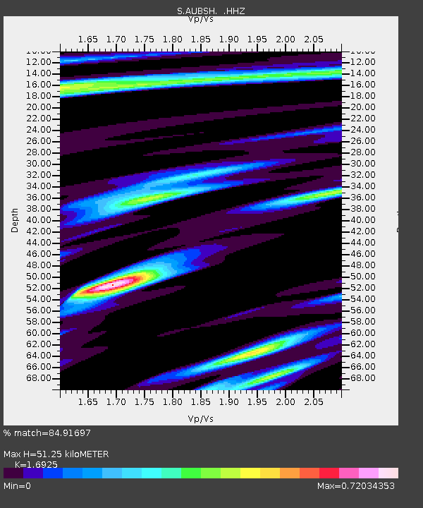
| Estimated Moho Depth: |
51.25 km |
| Estimated Crust Vp/Vs: |
1.69 |
| Assumed Crust Vp: |
6.472 km/s |
| Estimated Crust Vs: |
3.824 km/s |
| Estimated Crust Poisson's Ratio: |
0.23 |
|
| Radial Match: |
84.91697 % |
| Radial Bump: |
400 |
| Transverse Match: |
63.270374 % |
| Transverse Bump: |
400 |
| SOD ConfigId: |
827010 |
| Insert Time: |
2015-01-04 12:01:59.932 +0000 |
| GWidth: |
2.5 |
| Max Bumps: |
400 |
| Tol: |
0.001 |
|

Signal To Noise
| Channel | StoN | STA | LTA |
| S:AUBSH: :HHZ:20141221T11:41:00.610011Z | 4.1743984 | 4.4686476E-6 | 1.070489E-6 |
| S:AUBSH: :HHN:20141221T11:41:00.610011Z | 1.690188 | 1.3133803E-6 | 7.7706164E-7 |
| S:AUBSH: :HHE:20141221T11:41:00.610011Z | 3.4571993 | 2.3535767E-6 | 6.807755E-7 |
| Arrivals |
| Ps | 5.9 SECOND |
| PpPs | 20 SECOND |
| PsPs/PpSs | 26 SECOND |


