You are here: Home > Network List > IU - Global Seismograph Network (GSN - IRIS/USGS) Stations List
> Station JOHN Johnston Island, USA > Earthquake Result Viewer
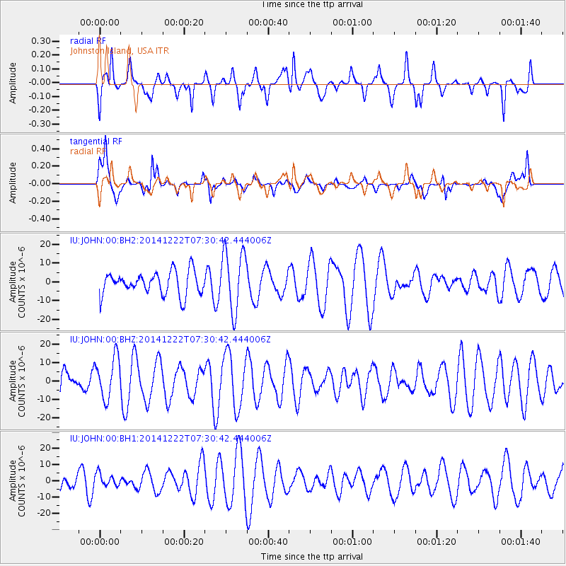
JOHN Johnston Island, USA - Earthquake Result Viewer
*The percent match for this event was below the threshold and hence no stack was calculated.
| Earthquake location: |
Pacific-Antarctic Ridge |
| Earthquake latitude/longitude: |
-54.2/-145.9 |
| Earthquake time(UTC): |
2014/12/22 (356) 07:19:41 GMT |
| Earthquake Depth: |
10 km |
| Earthquake Magnitude: |
5.8 MB |
| Earthquake Catalog/Contributor: |
NEIC PDE/NEIC COMCAT |
|
| Network: |
IU Global Seismograph Network (GSN - IRIS/USGS) |
| Station: |
JOHN Johnston Island, USA |
| Lat/Lon: |
16.73 N/169.53 W |
| Elevation: |
2.0 m |
|
| Distance: |
73.4 deg |
| Az: |
336.418 deg |
| Baz: |
165.782 deg |
| Ray Param: |
$rayparam |
*The percent match for this event was below the threshold and hence was not used in the summary stack. |
|
| Radial Match: |
50.185158 % |
| Radial Bump: |
371 |
| Transverse Match: |
71.591736 % |
| Transverse Bump: |
400 |
| SOD ConfigId: |
827288 |
| Insert Time: |
2015-01-05 07:34:47.325 +0000 |
| GWidth: |
2.5 |
| Max Bumps: |
400 |
| Tol: |
0.001 |
|
Signal To Noise
| Channel | StoN | STA | LTA |
| IU:JOHN:00:BHZ:20141222T07:30:42.444006Z | 1.2292523 | 1.1357701E-5 | 9.239519E-6 |
| IU:JOHN:00:BH1:20141222T07:30:42.444006Z | 0.71753263 | 3.9139677E-6 | 5.454759E-6 |
| IU:JOHN:00:BH2:20141222T07:30:42.444006Z | 2.7117739 | 1.655891E-5 | 6.106302E-6 |
| Arrivals |
| Ps | |
| PpPs | |
| PsPs/PpSs | |


