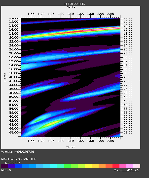
TIXI Tiksi, Russia - Earthquake Result Viewer
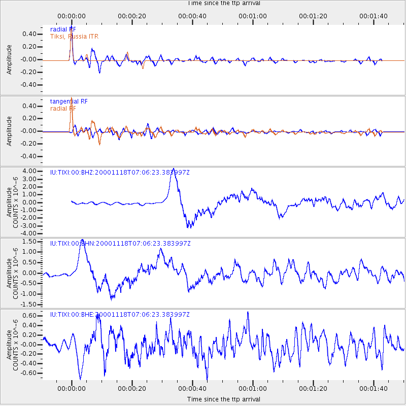
Earthquake location: New Britain Region, P.N.G.
Earthquake latitude/longitude: -5.2/151.8
Earthquake time(UTC): 2000/11/18 (323) 06:54:58 GMT
Earthquake Depth: 33 km
Earthquake Magnitude: 6.2 MB, 6.6 MS, 6.8 MW, 6.8 MW
Earthquake Catalog/Contributor: WHDF/NEIC
Network: IU Global Seismograph Network (GSN - IRIS/USGS)
Station: TIXI Tiksi, Russia
Lat/Lon: 71.65 N/128.87 E
Elevation: 50 m
Distance: 78.2 deg
Az: 352.765 deg
Baz: 156.673 deg
Ray Param: 0.0497666
Estimated Moho Depth: 15.0 km
Estimated Crust Vp/Vs: 2.08
Assumed Crust Vp: 6.552 km/s
Estimated Crust Vs: 3.154 km/s
Estimated Crust Poisson's Ratio: 0.35
Radial Match: 96.036736 %
Radial Bump: 400
Transverse Match: 77.76694 %
Transverse Bump: 400
SOD ConfigId: 3744
Insert Time: 2010-03-02 14:55:06.790 +0000
GWidth: 2.5
Max Bumps: 400
Tol: 0.001

Signal To Noise

ChannelStoNSTALTA
IU:TIXI:00:BHN:20001118T07:06:23.383997Z12.1457219.41848E-77.7545664E-8
IU:TIXI:00:BHE:20001118T07:06:23.383997Z5.40504363.4241722E-76.335142E-8
IU:TIXI:00:BHZ:20001118T07:06:23.383997Z21.706362.4674976E-61.1367624E-7
Arrivals
Ps2.5 SECOND
PpPs6.9 SECOND
PsPs/PpSs9.4 SECOND