You are here: Home > Network List > GS - US Geological Survey Networks Stations List
> Station KAN10 Keim Farm, Anthony, KS, USA > Earthquake Result Viewer
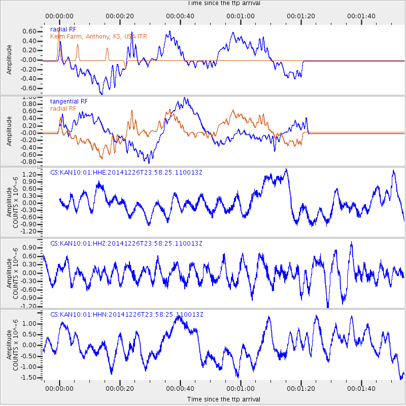
KAN10 Keim Farm, Anthony, KS, USA - Earthquake Result Viewer
*The percent match for this event was below the threshold and hence no stack was calculated.
| Earthquake location: |
South Of Panama |
| Earthquake latitude/longitude: |
6.5/-82.3 |
| Earthquake time(UTC): |
2014/12/26 (360) 23:52:14 GMT |
| Earthquake Depth: |
10 km |
| Earthquake Magnitude: |
5.5 MB |
| Earthquake Catalog/Contributor: |
NEIC PDE/NEIC COMCAT |
|
| Network: |
GS US Geological Survey Networks |
| Station: |
KAN10 Keim Farm, Anthony, KS, USA |
| Lat/Lon: |
37.12 N/98.10 W |
| Elevation: |
417 m |
|
| Distance: |
33.7 deg |
| Az: |
336.979 deg |
| Baz: |
150.911 deg |
| Ray Param: |
$rayparam |
*The percent match for this event was below the threshold and hence was not used in the summary stack. |
|
| Radial Match: |
39.741516 % |
| Radial Bump: |
400 |
| Transverse Match: |
69.39407 % |
| Transverse Bump: |
400 |
| SOD ConfigId: |
827389 |
| Insert Time: |
2015-01-10 00:26:04.035 +0000 |
| GWidth: |
2.5 |
| Max Bumps: |
400 |
| Tol: |
0.001 |
|
Signal To Noise
| Channel | StoN | STA | LTA |
| GS:KAN10:01:HHZ:20141226T23:58:25.110013Z | 1.2257682 | 3.3195698E-7 | 2.7081546E-7 |
| GS:KAN10:01:HHN:20141226T23:58:25.110013Z | 1.8554529 | 6.8062786E-7 | 3.6682573E-7 |
| GS:KAN10:01:HHE:20141226T23:58:25.110013Z | 1.5821183 | 5.3154173E-7 | 3.359684E-7 |
| Arrivals |
| Ps | |
| PpPs | |
| PsPs/PpSs | |


