You are here: Home > Network List > TA - USArray Transportable Network (new EarthScope stations) Stations List
> Station G59A Clarenceville, QC, USA > Earthquake Result Viewer
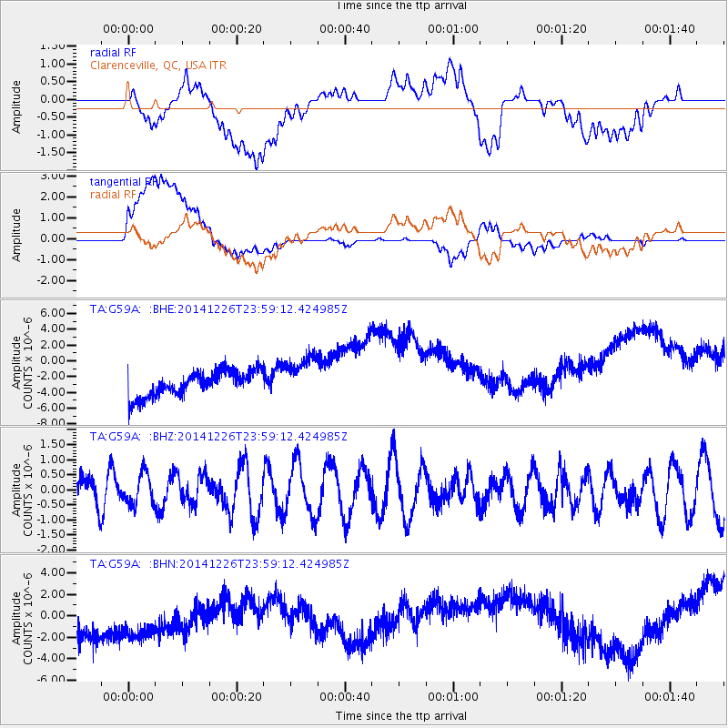
G59A Clarenceville, QC, USA - Earthquake Result Viewer
*The percent match for this event was below the threshold and hence no stack was calculated.
| Earthquake location: |
South Of Panama |
| Earthquake latitude/longitude: |
6.5/-82.3 |
| Earthquake time(UTC): |
2014/12/26 (360) 23:52:14 GMT |
| Earthquake Depth: |
10 km |
| Earthquake Magnitude: |
5.5 MB |
| Earthquake Catalog/Contributor: |
NEIC PDE/NEIC COMCAT |
|
| Network: |
TA USArray Transportable Network (new EarthScope stations) |
| Station: |
G59A Clarenceville, QC, USA |
| Lat/Lon: |
45.08 N/73.18 W |
| Elevation: |
36 m |
|
| Distance: |
39.2 deg |
| Az: |
10.273 deg |
| Baz: |
194.485 deg |
| Ray Param: |
$rayparam |
*The percent match for this event was below the threshold and hence was not used in the summary stack. |
|
| Radial Match: |
18.805332 % |
| Radial Bump: |
400 |
| Transverse Match: |
33.493862 % |
| Transverse Bump: |
400 |
| SOD ConfigId: |
827389 |
| Insert Time: |
2015-01-10 00:42:22.182 +0000 |
| GWidth: |
2.5 |
| Max Bumps: |
400 |
| Tol: |
0.001 |
|
Signal To Noise
| Channel | StoN | STA | LTA |
| TA:G59A: :BHZ:20141226T23:59:12.424985Z | 1.2713029 | 5.2633715E-7 | 4.1401395E-7 |
| TA:G59A: :BHN:20141226T23:59:12.424985Z | 0.9424507 | 5.399388E-6 | 5.729093E-6 |
| TA:G59A: :BHE:20141226T23:59:12.424985Z | 1.7183973 | 2.7615965E-6 | 1.6070769E-6 |
| Arrivals |
| Ps | |
| PpPs | |
| PsPs/PpSs | |


