You are here: Home > Network List > TA - USArray Transportable Network (new EarthScope stations) Stations List
> Station L04D Klamath Falls, OR, USA > Earthquake Result Viewer
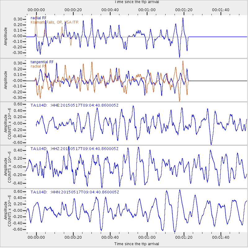
L04D Klamath Falls, OR, USA - Earthquake Result Viewer
*The percent match for this event was below the threshold and hence no stack was calculated.
| Earthquake location: |
Santa Cruz Islands |
| Earthquake latitude/longitude: |
-12.2/165.8 |
| Earthquake time(UTC): |
2015/05/17 (137) 08:52:37 GMT |
| Earthquake Depth: |
18 km |
| Earthquake Magnitude: |
5.6 MW, 5.5 mb, 5.3 MS |
| Earthquake Catalog/Contributor: |
ISC/ISC |
|
| Network: |
TA USArray Transportable Network (new EarthScope stations) |
| Station: |
L04D Klamath Falls, OR, USA |
| Lat/Lon: |
42.22 N/122.30 W |
| Elevation: |
1437 m |
|
| Distance: |
85.1 deg |
| Az: |
45.123 deg |
| Baz: |
248.872 deg |
| Ray Param: |
$rayparam |
*The percent match for this event was below the threshold and hence was not used in the summary stack. |
|
| Radial Match: |
54.46658 % |
| Radial Bump: |
392 |
| Transverse Match: |
30.008091 % |
| Transverse Bump: |
276 |
| SOD ConfigId: |
7422571 |
| Insert Time: |
2019-04-18 22:26:22.031 +0000 |
| GWidth: |
2.5 |
| Max Bumps: |
400 |
| Tol: |
0.001 |
|
Signal To Noise
| Channel | StoN | STA | LTA |
| TA:L04D: :HHZ:20150517T09:04:40.860005Z | 0.606218 | 1.12064235E-7 | 1.8485798E-7 |
| TA:L04D: :HHN:20150517T09:04:40.860005Z | 1.2526206 | 2.1195405E-7 | 1.6920849E-7 |
| TA:L04D: :HHE:20150517T09:04:40.860005Z | 2.322338 | 3.2492494E-7 | 1.3991284E-7 |
| Arrivals |
| Ps | |
| PpPs | |
| PsPs/PpSs | |


