You are here: Home > Network List > AZ - ANZA Regional Network Stations List
> Station SMER AZ.SMER > Earthquake Result Viewer
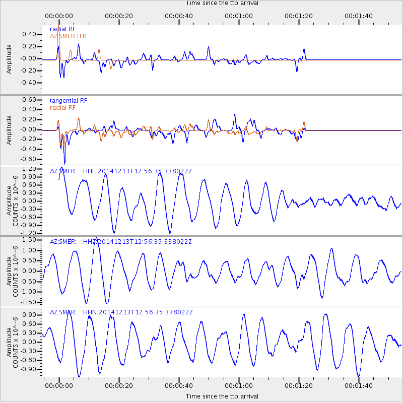
SMER AZ.SMER - Earthquake Result Viewer
*The percent match for this event was below the threshold and hence no stack was calculated.
| Earthquake location: |
Easter Island Region |
| Earthquake latitude/longitude: |
-29.0/-112.2 |
| Earthquake time(UTC): |
2014/12/13 (347) 12:46:44 GMT |
| Earthquake Depth: |
10 km |
| Earthquake Magnitude: |
5.5 MWC, 5.4 MWB, 5.5 MWC |
| Earthquake Catalog/Contributor: |
NEIC PDE/NEIC COMCAT |
|
| Network: |
AZ ANZA Regional Network |
| Station: |
SMER AZ.SMER |
| Lat/Lon: |
33.46 N/117.17 W |
| Elevation: |
355 m |
|
| Distance: |
62.3 deg |
| Az: |
355.316 deg |
| Baz: |
175.09 deg |
| Ray Param: |
$rayparam |
*The percent match for this event was below the threshold and hence was not used in the summary stack. |
|
| Radial Match: |
79.15202 % |
| Radial Bump: |
400 |
| Transverse Match: |
73.79339 % |
| Transverse Bump: |
400 |
| SOD ConfigId: |
827991 |
| Insert Time: |
2015-01-20 18:37:31.686 +0000 |
| GWidth: |
2.5 |
| Max Bumps: |
400 |
| Tol: |
0.001 |
|
Signal To Noise
| Channel | StoN | STA | LTA |
| AZ:SMER: :HHZ:20141213T12:56:35.338022Z | 2.0788348 | 6.714593E-7 | 3.2299795E-7 |
| AZ:SMER: :HHN:20141213T12:56:35.338022Z | 2.762384 | 6.686971E-7 | 2.4207247E-7 |
| AZ:SMER: :HHE:20141213T12:56:35.338022Z | 1.2308083 | 7.670798E-7 | 6.2323255E-7 |
| Arrivals |
| Ps | |
| PpPs | |
| PsPs/PpSs | |


