You are here: Home > Network List > TA - USArray Transportable Network (new EarthScope stations) Stations List
> Station U58A Oxford, NC, USA > Earthquake Result Viewer
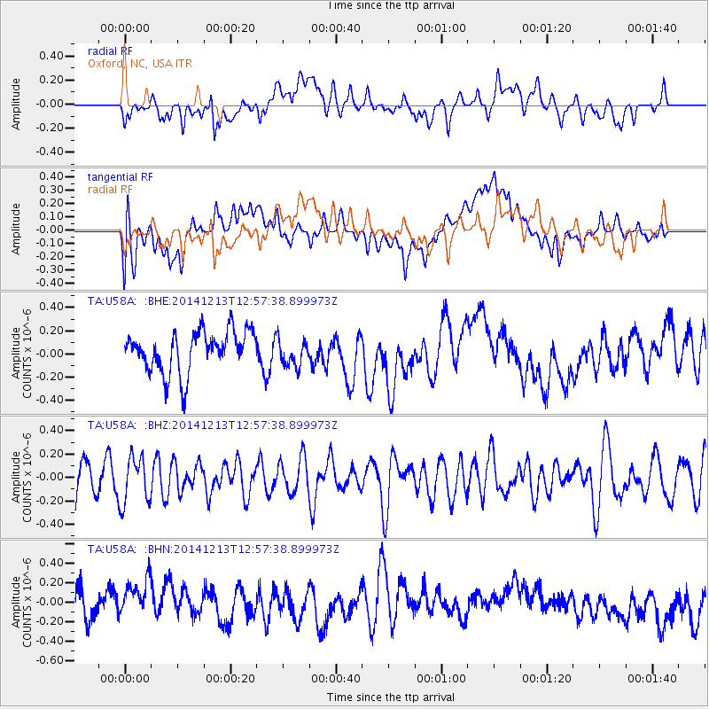
U58A Oxford, NC, USA - Earthquake Result Viewer
*The percent match for this event was below the threshold and hence no stack was calculated.
| Earthquake location: |
Easter Island Region |
| Earthquake latitude/longitude: |
-29.0/-112.2 |
| Earthquake time(UTC): |
2014/12/13 (347) 12:46:44 GMT |
| Earthquake Depth: |
10 km |
| Earthquake Magnitude: |
5.5 MWC, 5.4 MWB, 5.5 MWC |
| Earthquake Catalog/Contributor: |
NEIC PDE/NEIC COMCAT |
|
| Network: |
TA USArray Transportable Network (new EarthScope stations) |
| Station: |
U58A Oxford, NC, USA |
| Lat/Lon: |
36.39 N/78.55 W |
| Elevation: |
169 m |
|
| Distance: |
72.3 deg |
| Az: |
27.997 deg |
| Baz: |
210.652 deg |
| Ray Param: |
$rayparam |
*The percent match for this event was below the threshold and hence was not used in the summary stack. |
|
| Radial Match: |
42.95456 % |
| Radial Bump: |
400 |
| Transverse Match: |
47.48589 % |
| Transverse Bump: |
400 |
| SOD ConfigId: |
827991 |
| Insert Time: |
2015-01-20 18:58:10.440 +0000 |
| GWidth: |
2.5 |
| Max Bumps: |
400 |
| Tol: |
0.001 |
|
Signal To Noise
| Channel | StoN | STA | LTA |
| TA:U58A: :BHZ:20141213T12:57:38.899973Z | 1.0599941 | 2.0006297E-7 | 1.887397E-7 |
| TA:U58A: :BHN:20141213T12:57:38.899973Z | 1.4936295 | 2.5034709E-7 | 1.676099E-7 |
| TA:U58A: :BHE:20141213T12:57:38.899973Z | 0.63601935 | 1.13638436E-7 | 1.7867134E-7 |
| Arrivals |
| Ps | |
| PpPs | |
| PsPs/PpSs | |


