You are here: Home > Network List > TA - USArray Transportable Network (new EarthScope stations) Stations List
> Station V55A Taylorsville, NC, USA > Earthquake Result Viewer
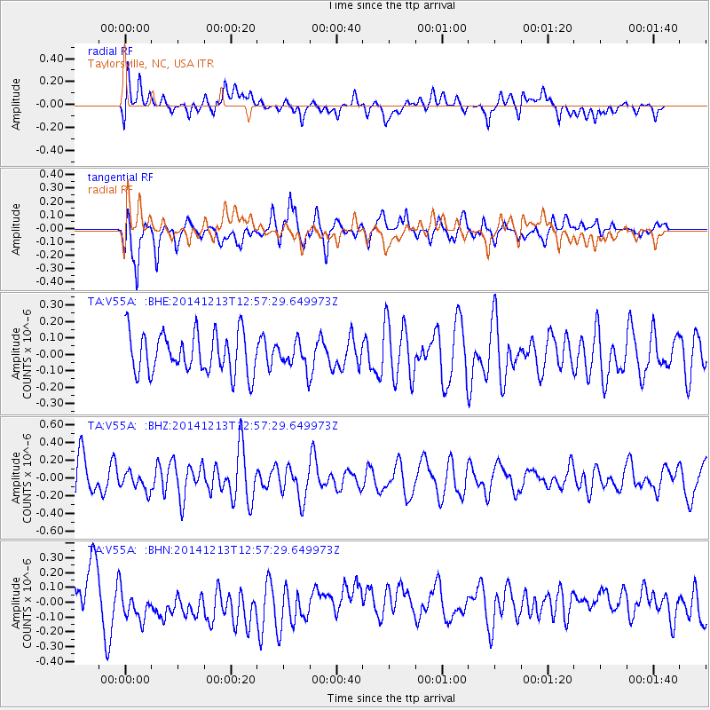
V55A Taylorsville, NC, USA - Earthquake Result Viewer
*The percent match for this event was below the threshold and hence no stack was calculated.
| Earthquake location: |
Easter Island Region |
| Earthquake latitude/longitude: |
-29.0/-112.2 |
| Earthquake time(UTC): |
2014/12/13 (347) 12:46:44 GMT |
| Earthquake Depth: |
10 km |
| Earthquake Magnitude: |
5.5 MWC, 5.4 MWB, 5.5 MWC |
| Earthquake Catalog/Contributor: |
NEIC PDE/NEIC COMCAT |
|
| Network: |
TA USArray Transportable Network (new EarthScope stations) |
| Station: |
V55A Taylorsville, NC, USA |
| Lat/Lon: |
35.85 N/81.21 W |
| Elevation: |
306 m |
|
| Distance: |
70.8 deg |
| Az: |
26.301 deg |
| Baz: |
208.55 deg |
| Ray Param: |
$rayparam |
*The percent match for this event was below the threshold and hence was not used in the summary stack. |
|
| Radial Match: |
39.836044 % |
| Radial Bump: |
400 |
| Transverse Match: |
60.33524 % |
| Transverse Bump: |
400 |
| SOD ConfigId: |
827991 |
| Insert Time: |
2015-01-20 18:58:17.461 +0000 |
| GWidth: |
2.5 |
| Max Bumps: |
400 |
| Tol: |
0.001 |
|
Signal To Noise
| Channel | StoN | STA | LTA |
| TA:V55A: :BHZ:20141213T12:57:29.649973Z | 0.57431173 | 1.0635757E-7 | 1.8519135E-7 |
| TA:V55A: :BHN:20141213T12:57:29.649973Z | 1.1998899 | 1.8904831E-7 | 1.5755471E-7 |
| TA:V55A: :BHE:20141213T12:57:29.649973Z | 0.6350031 | 7.870904E-8 | 1.2395066E-7 |
| Arrivals |
| Ps | |
| PpPs | |
| PsPs/PpSs | |


