You are here: Home > Network List > US - United States National Seismic Network Stations List
> Station HAWA Hanford, Washington, USA > Earthquake Result Viewer
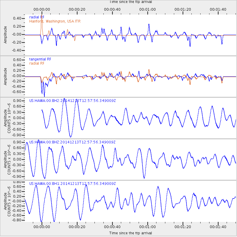
HAWA Hanford, Washington, USA - Earthquake Result Viewer
*The percent match for this event was below the threshold and hence no stack was calculated.
| Earthquake location: |
Easter Island Region |
| Earthquake latitude/longitude: |
-29.0/-112.2 |
| Earthquake time(UTC): |
2014/12/13 (347) 12:46:44 GMT |
| Earthquake Depth: |
10 km |
| Earthquake Magnitude: |
5.5 MWC, 5.4 MWB, 5.5 MWC |
| Earthquake Catalog/Contributor: |
NEIC PDE/NEIC COMCAT |
|
| Network: |
US United States National Seismic Network |
| Station: |
HAWA Hanford, Washington, USA |
| Lat/Lon: |
46.39 N/119.53 W |
| Elevation: |
364 m |
|
| Distance: |
75.3 deg |
| Az: |
354.768 deg |
| Baz: |
173.371 deg |
| Ray Param: |
$rayparam |
*The percent match for this event was below the threshold and hence was not used in the summary stack. |
|
| Radial Match: |
47.385235 % |
| Radial Bump: |
400 |
| Transverse Match: |
72.50454 % |
| Transverse Bump: |
400 |
| SOD ConfigId: |
827991 |
| Insert Time: |
2015-01-20 18:59:45.046 +0000 |
| GWidth: |
2.5 |
| Max Bumps: |
400 |
| Tol: |
0.001 |
|
Signal To Noise
| Channel | StoN | STA | LTA |
| US:HAWA:00:BHZ:20141213T12:57:56.349009Z | 1.0156801 | 6.2287796E-7 | 6.1326193E-7 |
| US:HAWA:00:BH1:20141213T12:57:56.349009Z | 2.4835358 | 5.5328434E-7 | 2.227809E-7 |
| US:HAWA:00:BH2:20141213T12:57:56.349009Z | 0.42489627 | 2.3535351E-7 | 5.5390814E-7 |
| Arrivals |
| Ps | |
| PpPs | |
| PsPs/PpSs | |


