You are here: Home > Network List > TA - USArray Transportable Network (new EarthScope stations) Stations List
> Station I23K Minto, Yukon-Koyukuk, AK, USA > Earthquake Result Viewer
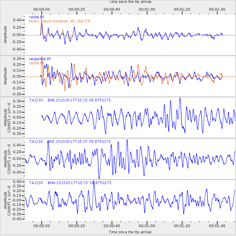
I23K Minto, Yukon-Koyukuk, AK, USA - Earthquake Result Viewer
*The percent match for this event was below the threshold and hence no stack was calculated.
| Earthquake location: |
South Of Mariana Islands |
| Earthquake latitude/longitude: |
12.9/146.2 |
| Earthquake time(UTC): |
2015/05/17 (137) 16:15:15 GMT |
| Earthquake Depth: |
35 km |
| Earthquake Magnitude: |
5.1 MW, 5.2 mb, 4.5 MS |
| Earthquake Catalog/Contributor: |
ISC/ISC |
|
| Network: |
TA USArray Transportable Network (new EarthScope stations) |
| Station: |
I23K Minto, Yukon-Koyukuk, AK, USA |
| Lat/Lon: |
65.15 N/149.36 W |
| Elevation: |
149 m |
|
| Distance: |
67.7 deg |
| Az: |
24.335 deg |
| Baz: |
251.944 deg |
| Ray Param: |
$rayparam |
*The percent match for this event was below the threshold and hence was not used in the summary stack. |
|
| Radial Match: |
65.595985 % |
| Radial Bump: |
353 |
| Transverse Match: |
58.51331 % |
| Transverse Bump: |
395 |
| SOD ConfigId: |
7422571 |
| Insert Time: |
2019-04-18 22:32:38.575 +0000 |
| GWidth: |
2.5 |
| Max Bumps: |
400 |
| Tol: |
0.001 |
|
Signal To Noise
| Channel | StoN | STA | LTA |
| TA:I23K: :BHZ:20150517T16:25:38.875027Z | 2.3024151 | 2.0380018E-7 | 8.851583E-8 |
| TA:I23K: :BHN:20150517T16:25:38.875027Z | 0.9976547 | 8.47076E-8 | 8.490674E-8 |
| TA:I23K: :BHE:20150517T16:25:38.875027Z | 1.9411757 | 1.2542284E-7 | 6.46118E-8 |
| Arrivals |
| Ps | |
| PpPs | |
| PsPs/PpSs | |


