You are here: Home > Network List > TJ - Tajikistan National Seismic Network Stations List
> Station SHAA Shaartuz, Tajikistan > Earthquake Result Viewer
SHAA Shaartuz, Tajikistan - Earthquake Result Viewer
| Earthquake location: |
South Of Mariana Islands |
| Earthquake latitude/longitude: |
12.9/146.2 |
| Earthquake time(UTC): |
2015/05/17 (137) 16:15:15 GMT |
| Earthquake Depth: |
35 km |
| Earthquake Magnitude: |
5.1 MW, 5.2 mb, 4.5 MS |
| Earthquake Catalog/Contributor: |
ISC/ISC |
|
| Network: |
TJ Tajikistan National Seismic Network |
| Station: |
SHAA Shaartuz, Tajikistan |
| Lat/Lon: |
37.56 N/68.12 E |
| Elevation: |
868 m |
|
| Distance: |
72.8 deg |
| Az: |
305.54 deg |
| Baz: |
86.779 deg |
| Ray Param: |
0.05335852 |
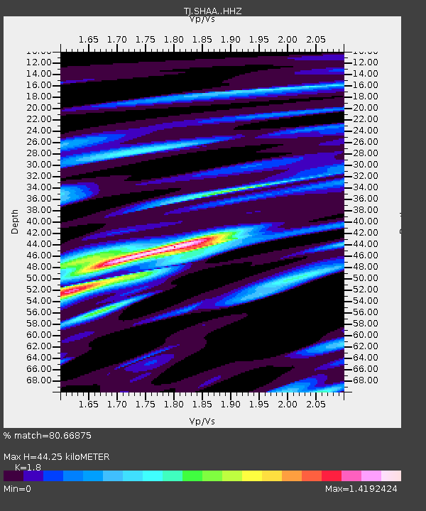
| Estimated Moho Depth: |
44.25 km |
| Estimated Crust Vp/Vs: |
1.80 |
| Assumed Crust Vp: |
6.213 km/s |
| Estimated Crust Vs: |
3.452 km/s |
| Estimated Crust Poisson's Ratio: |
0.28 |
|
| Radial Match: |
80.66875 % |
| Radial Bump: |
400 |
| Transverse Match: |
66.229744 % |
| Transverse Bump: |
400 |
| SOD ConfigId: |
7422571 |
| Insert Time: |
2019-04-18 22:32:50.698 +0000 |
| GWidth: |
2.5 |
| Max Bumps: |
400 |
| Tol: |
0.001 |
|

Signal To Noise
| Channel | StoN | STA | LTA |
| TJ:SHAA: :HHZ:20150517T16:26:09.779995Z | 4.5756083 | 1.5804548E-6 | 3.4540867E-7 |
| TJ:SHAA: :HHN:20150517T16:26:09.779995Z | 0.75965816 | 1.5731618E-7 | 2.070881E-7 |
| TJ:SHAA: :HHE:20150517T16:26:09.779995Z | 2.2080197 | 5.129843E-7 | 2.3232776E-7 |
| Arrivals |
| Ps | 5.9 SECOND |
| PpPs | 19 SECOND |
| PsPs/PpSs | 25 SECOND |


