You are here: Home > Network List > AV - Alaska Volcano Observatory Stations List
> Station AMKA Regional Station, Amchitka Island, Alaska > Earthquake Result Viewer
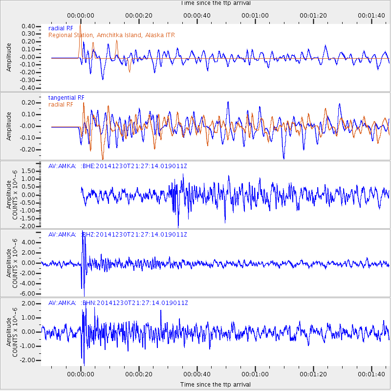
AMKA Regional Station, Amchitka Island, Alaska - Earthquake Result Viewer
*The percent match for this event was below the threshold and hence no stack was calculated.
| Earthquake location: |
Fiji Islands Region |
| Earthquake latitude/longitude: |
-20.3/-178.5 |
| Earthquake time(UTC): |
2014/12/30 (364) 21:17:23 GMT |
| Earthquake Depth: |
598 km |
| Earthquake Magnitude: |
6.1 MWB |
| Earthquake Catalog/Contributor: |
NEIC PDE/NEIC COMCAT |
|
| Network: |
AV Alaska Volcano Observatory |
| Station: |
AMKA Regional Station, Amchitka Island, Alaska |
| Lat/Lon: |
51.38 N/179.30 E |
| Elevation: |
116 m |
|
| Distance: |
71.4 deg |
| Az: |
358.578 deg |
| Baz: |
177.871 deg |
| Ray Param: |
$rayparam |
*The percent match for this event was below the threshold and hence was not used in the summary stack. |
|
| Radial Match: |
53.26865 % |
| Radial Bump: |
400 |
| Transverse Match: |
49.91536 % |
| Transverse Bump: |
400 |
| SOD ConfigId: |
827991 |
| Insert Time: |
2015-01-20 19:09:45.140 +0000 |
| GWidth: |
2.5 |
| Max Bumps: |
400 |
| Tol: |
0.001 |
|
Signal To Noise
| Channel | StoN | STA | LTA |
| AV:AMKA: :BHZ:20141230T21:27:14.019011Z | 7.58918 | 2.2883464E-6 | 3.0152748E-7 |
| AV:AMKA: :BHN:20141230T21:27:14.019011Z | 2.8762484 | 8.6000995E-7 | 2.9900406E-7 |
| AV:AMKA: :BHE:20141230T21:27:14.019011Z | 2.7010405 | 6.3164674E-7 | 2.3385311E-7 |
| Arrivals |
| Ps | |
| PpPs | |
| PsPs/PpSs | |


