You are here: Home > Network List > TA - USArray Transportable Network (new EarthScope stations) Stations List
> Station D04E Lakebay, WA, USA > Earthquake Result Viewer
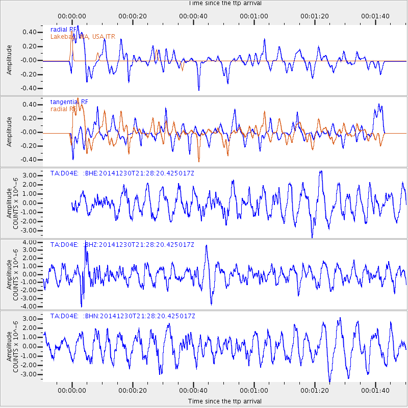
D04E Lakebay, WA, USA - Earthquake Result Viewer
*The percent match for this event was below the threshold and hence no stack was calculated.
| Earthquake location: |
Fiji Islands Region |
| Earthquake latitude/longitude: |
-20.3/-178.5 |
| Earthquake time(UTC): |
2014/12/30 (364) 21:17:23 GMT |
| Earthquake Depth: |
598 km |
| Earthquake Magnitude: |
6.1 MWB |
| Earthquake Catalog/Contributor: |
NEIC PDE/NEIC COMCAT |
|
| Network: |
TA USArray Transportable Network (new EarthScope stations) |
| Station: |
D04E Lakebay, WA, USA |
| Lat/Lon: |
47.18 N/122.77 W |
| Elevation: |
45 m |
|
| Distance: |
83.8 deg |
| Az: |
34.564 deg |
| Baz: |
231.299 deg |
| Ray Param: |
$rayparam |
*The percent match for this event was below the threshold and hence was not used in the summary stack. |
|
| Radial Match: |
51.70778 % |
| Radial Bump: |
400 |
| Transverse Match: |
58.104137 % |
| Transverse Bump: |
400 |
| SOD ConfigId: |
827991 |
| Insert Time: |
2015-01-20 19:24:10.469 +0000 |
| GWidth: |
2.5 |
| Max Bumps: |
400 |
| Tol: |
0.001 |
|
Signal To Noise
| Channel | StoN | STA | LTA |
| TA:D04E: :BHZ:20141230T21:28:20.425017Z | 1.901672 | 1.5927138E-6 | 8.375334E-7 |
| TA:D04E: :BHN:20141230T21:28:20.425017Z | 0.85799384 | 1.0002145E-6 | 1.1657595E-6 |
| TA:D04E: :BHE:20141230T21:28:20.425017Z | 1.3917465 | 1.1920957E-6 | 8.5654654E-7 |
| Arrivals |
| Ps | |
| PpPs | |
| PsPs/PpSs | |


