You are here: Home > Network List > TA - USArray Transportable Network (new EarthScope stations) Stations List
> Station G03D McMinnville, OR, USA > Earthquake Result Viewer
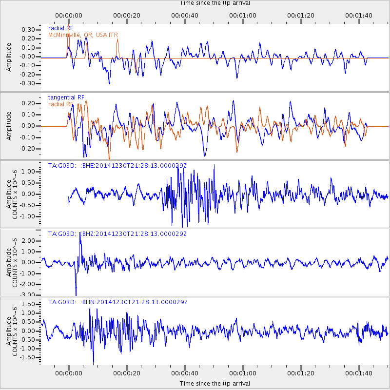
G03D McMinnville, OR, USA - Earthquake Result Viewer
*The percent match for this event was below the threshold and hence no stack was calculated.
| Earthquake location: |
Fiji Islands Region |
| Earthquake latitude/longitude: |
-20.3/-178.5 |
| Earthquake time(UTC): |
2014/12/30 (364) 21:17:23 GMT |
| Earthquake Depth: |
598 km |
| Earthquake Magnitude: |
6.1 MWB |
| Earthquake Catalog/Contributor: |
NEIC PDE/NEIC COMCAT |
|
| Network: |
TA USArray Transportable Network (new EarthScope stations) |
| Station: |
G03D McMinnville, OR, USA |
| Lat/Lon: |
45.21 N/123.26 W |
| Elevation: |
222 m |
|
| Distance: |
82.3 deg |
| Az: |
35.893 deg |
| Baz: |
231.105 deg |
| Ray Param: |
$rayparam |
*The percent match for this event was below the threshold and hence was not used in the summary stack. |
|
| Radial Match: |
51.380436 % |
| Radial Bump: |
400 |
| Transverse Match: |
54.707314 % |
| Transverse Bump: |
400 |
| SOD ConfigId: |
827991 |
| Insert Time: |
2015-01-20 19:24:23.553 +0000 |
| GWidth: |
2.5 |
| Max Bumps: |
400 |
| Tol: |
0.001 |
|
Signal To Noise
| Channel | StoN | STA | LTA |
| TA:G03D: :BHZ:20141230T21:28:13.000029Z | 5.663617 | 1.0835796E-6 | 1.913229E-7 |
| TA:G03D: :BHN:20141230T21:28:13.000029Z | 1.1594877 | 3.1643393E-7 | 2.7290838E-7 |
| TA:G03D: :BHE:20141230T21:28:13.000029Z | 1.5408564 | 2.8950353E-7 | 1.8788484E-7 |
| Arrivals |
| Ps | |
| PpPs | |
| PsPs/PpSs | |


