You are here: Home > Network List > GS - US Geological Survey Networks Stations List
> Station OK031 2598 S. Brethren Rd., Cushing, OK, USA > Earthquake Result Viewer
OK031 2598 S. Brethren Rd., Cushing, OK, USA - Earthquake Result Viewer
| Earthquake location: |
Kuril Islands |
| Earthquake latitude/longitude: |
44.5/146.5 |
| Earthquake time(UTC): |
2015/05/17 (137) 17:26:02 GMT |
| Earthquake Depth: |
168 km |
| Earthquake Magnitude: |
3.6 mb |
| Earthquake Catalog/Contributor: |
ISC/ISC |
|
| Network: |
GS US Geological Survey Networks |
| Station: |
OK031 2598 S. Brethren Rd., Cushing, OK, USA |
| Lat/Lon: |
35.95 N/96.84 W |
| Elevation: |
290 m |
|
| Distance: |
81.5 deg |
| Az: |
47.16 deg |
| Baz: |
319.738 deg |
| Ray Param: |
0.047156885 |
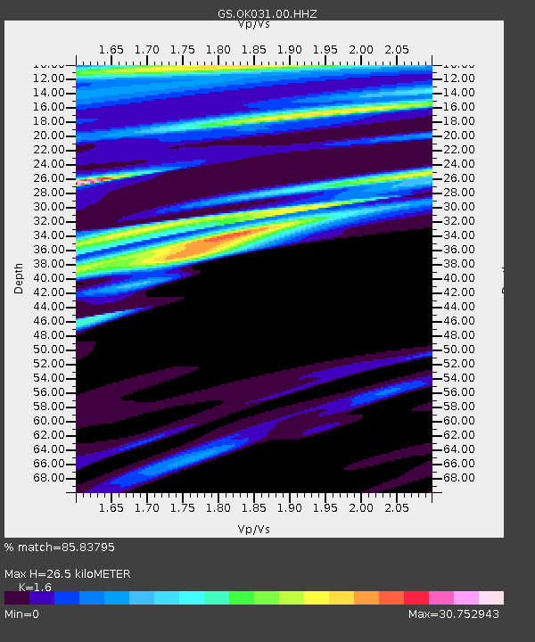
| Estimated Moho Depth: |
26.5 km |
| Estimated Crust Vp/Vs: |
1.60 |
| Assumed Crust Vp: |
6.426 km/s |
| Estimated Crust Vs: |
4.016 km/s |
| Estimated Crust Poisson's Ratio: |
0.18 |
|
| Radial Match: |
85.83795 % |
| Radial Bump: |
291 |
| Transverse Match: |
85.49468 % |
| Transverse Bump: |
299 |
| SOD ConfigId: |
7422571 |
| Insert Time: |
2019-04-18 22:37:18.484 +0000 |
| GWidth: |
2.5 |
| Max Bumps: |
400 |
| Tol: |
0.001 |
|
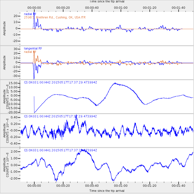
Signal To Noise
| Channel | StoN | STA | LTA |
| GS:OK031:00:HHZ:20150517T17:37:29.473994Z | 0.5601226 | 7.750666E-8 | 1.3837447E-7 |
| GS:OK031:00:HH1:20150517T17:37:29.473994Z | 1.9447284 | 9.738222E-7 | 5.0074976E-7 |
| GS:OK031:00:HH2:20150517T17:37:29.473994Z | 0.25217152 | 1.6723117E-6 | 6.631644E-6 |
| Arrivals |
| Ps | 2.5 SECOND |
| PpPs | 10 SECOND |
| PsPs/PpSs | 13 SECOND |


