You are here: Home > Network List > US - United States National Seismic Network Stations List
> Station MNTX Cornudas Mountains, Texas, USA > Earthquake Result Viewer
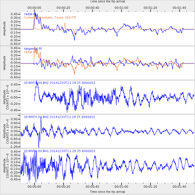
MNTX Cornudas Mountains, Texas, USA - Earthquake Result Viewer
*The percent match for this event was below the threshold and hence no stack was calculated.
| Earthquake location: |
Fiji Islands Region |
| Earthquake latitude/longitude: |
-20.3/-178.5 |
| Earthquake time(UTC): |
2014/12/30 (364) 21:17:23 GMT |
| Earthquake Depth: |
598 km |
| Earthquake Magnitude: |
6.1 MWB |
| Earthquake Catalog/Contributor: |
NEIC PDE/NEIC COMCAT |
|
| Network: |
US United States National Seismic Network |
| Station: |
MNTX Cornudas Mountains, Texas, USA |
| Lat/Lon: |
31.70 N/105.38 W |
| Elevation: |
404 m |
|
| Distance: |
87.1 deg |
| Az: |
54.779 deg |
| Baz: |
244.073 deg |
| Ray Param: |
$rayparam |
*The percent match for this event was below the threshold and hence was not used in the summary stack. |
|
| Radial Match: |
61.721462 % |
| Radial Bump: |
400 |
| Transverse Match: |
66.57764 % |
| Transverse Bump: |
400 |
| SOD ConfigId: |
827991 |
| Insert Time: |
2015-01-20 19:26:49.199 +0000 |
| GWidth: |
2.5 |
| Max Bumps: |
400 |
| Tol: |
0.001 |
|
Signal To Noise
| Channel | StoN | STA | LTA |
| US:MNTX:00:BHZ:20141230T21:28:35.899993Z | 2.2779007 | 4.6798962E-7 | 2.0544776E-7 |
| US:MNTX:00:BH1:20141230T21:28:35.899993Z | 1.6403508 | 2.157932E-7 | 1.3155307E-7 |
| US:MNTX:00:BH2:20141230T21:28:35.899993Z | 1.4076242 | 2.2545997E-7 | 1.6017056E-7 |
| Arrivals |
| Ps | |
| PpPs | |
| PsPs/PpSs | |


