You are here: Home > Network List > US - United States National Seismic Network Stations List
> Station WUAZ Wupatki, Arizona, USA > Earthquake Result Viewer
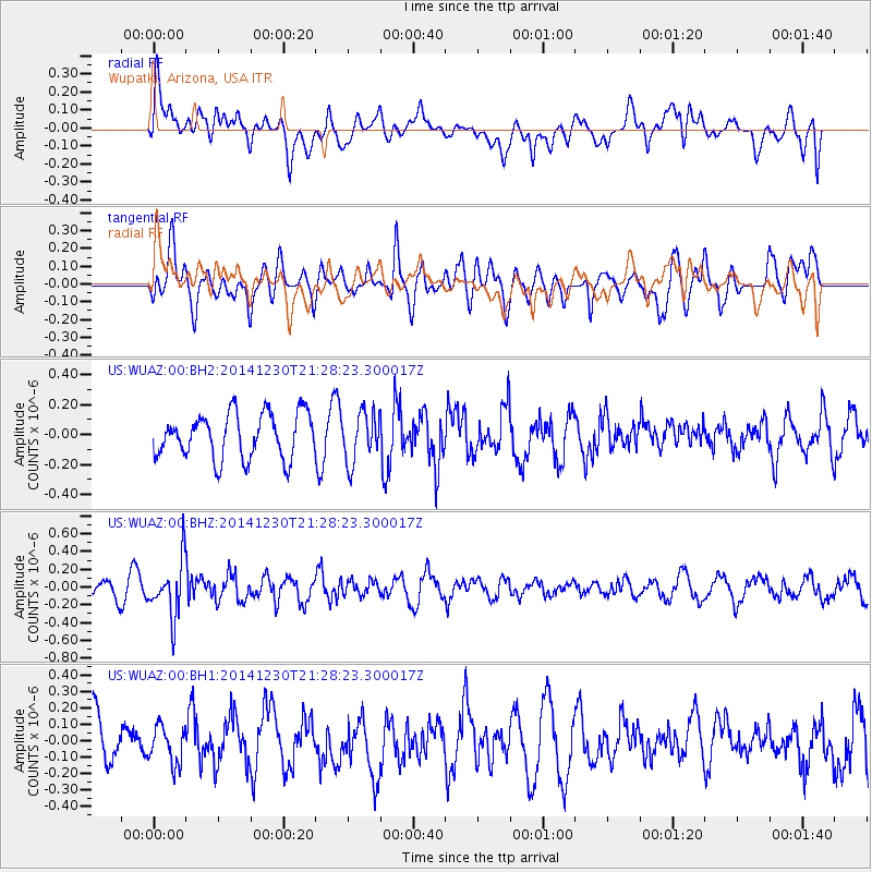
WUAZ Wupatki, Arizona, USA - Earthquake Result Viewer
*The percent match for this event was below the threshold and hence no stack was calculated.
| Earthquake location: |
Fiji Islands Region |
| Earthquake latitude/longitude: |
-20.3/-178.5 |
| Earthquake time(UTC): |
2014/12/30 (364) 21:17:23 GMT |
| Earthquake Depth: |
598 km |
| Earthquake Magnitude: |
6.1 MWB |
| Earthquake Catalog/Contributor: |
NEIC PDE/NEIC COMCAT |
|
| Network: |
US United States National Seismic Network |
| Station: |
WUAZ Wupatki, Arizona, USA |
| Lat/Lon: |
35.52 N/111.37 W |
| Elevation: |
1592 m |
|
| Distance: |
84.4 deg |
| Az: |
49.066 deg |
| Baz: |
240.344 deg |
| Ray Param: |
$rayparam |
*The percent match for this event was below the threshold and hence was not used in the summary stack. |
|
| Radial Match: |
39.30405 % |
| Radial Bump: |
400 |
| Transverse Match: |
57.67108 % |
| Transverse Bump: |
400 |
| SOD ConfigId: |
827991 |
| Insert Time: |
2015-01-20 19:27:26.955 +0000 |
| GWidth: |
2.5 |
| Max Bumps: |
400 |
| Tol: |
0.001 |
|
Signal To Noise
| Channel | StoN | STA | LTA |
| US:WUAZ:00:BHZ:20141230T21:28:23.300017Z | 3.7386267 | 3.1330654E-7 | 8.3802576E-8 |
| US:WUAZ:00:BH1:20141230T21:28:23.300017Z | 0.8117686 | 1.1176654E-7 | 1.3768275E-7 |
| US:WUAZ:00:BH2:20141230T21:28:23.300017Z | 1.1154135 | 1.6531898E-7 | 1.4821318E-7 |
| Arrivals |
| Ps | |
| PpPs | |
| PsPs/PpSs | |


