You are here: Home > Network List > UW - Pacific Northwest Regional Seismic Network Stations List
> Station MRBL Marblemount, WA, USA > Earthquake Result Viewer
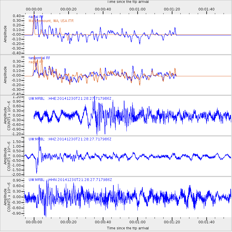
MRBL Marblemount, WA, USA - Earthquake Result Viewer
*The percent match for this event was below the threshold and hence no stack was calculated.
| Earthquake location: |
Fiji Islands Region |
| Earthquake latitude/longitude: |
-20.3/-178.5 |
| Earthquake time(UTC): |
2014/12/30 (364) 21:17:23 GMT |
| Earthquake Depth: |
598 km |
| Earthquake Magnitude: |
6.1 MWB |
| Earthquake Catalog/Contributor: |
NEIC PDE/NEIC COMCAT |
|
| Network: |
UW Pacific Northwest Regional Seismic Network |
| Station: |
MRBL Marblemount, WA, USA |
| Lat/Lon: |
48.52 N/121.48 W |
| Elevation: |
75 m |
|
| Distance: |
85.3 deg |
| Az: |
34.046 deg |
| Baz: |
232.202 deg |
| Ray Param: |
$rayparam |
*The percent match for this event was below the threshold and hence was not used in the summary stack. |
|
| Radial Match: |
57.089554 % |
| Radial Bump: |
400 |
| Transverse Match: |
50.26124 % |
| Transverse Bump: |
400 |
| SOD ConfigId: |
827991 |
| Insert Time: |
2015-01-20 19:29:24.635 +0000 |
| GWidth: |
2.5 |
| Max Bumps: |
400 |
| Tol: |
0.001 |
|
Signal To Noise
| Channel | StoN | STA | LTA |
| UW:MRBL: :HHZ:20141230T21:28:27.717986Z | 6.776742 | 8.100958E-7 | 1.195406E-7 |
| UW:MRBL: :HHN:20141230T21:28:27.717986Z | 1.7922804 | 2.697086E-7 | 1.5048349E-7 |
| UW:MRBL: :HHE:20141230T21:28:27.717986Z | 2.1949852 | 4.2452783E-7 | 1.9340806E-7 |
| Arrivals |
| Ps | |
| PpPs | |
| PsPs/PpSs | |


