You are here: Home > Network List > WY - Yellowstone Wyoming Seismic Network Stations List
> Station YHH Holmes Hill, YNP, WY, USA > Earthquake Result Viewer
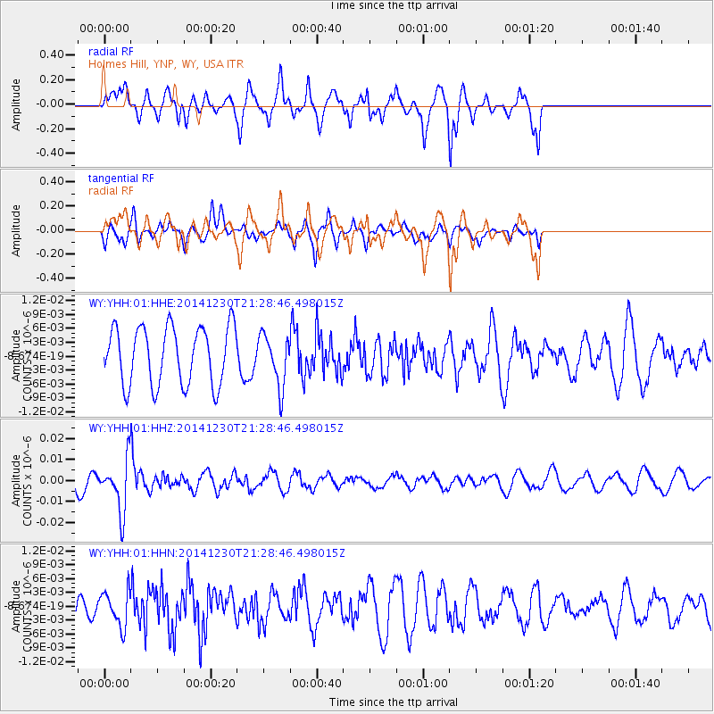
YHH Holmes Hill, YNP, WY, USA - Earthquake Result Viewer
*The percent match for this event was below the threshold and hence no stack was calculated.
| Earthquake location: |
Fiji Islands Region |
| Earthquake latitude/longitude: |
-20.3/-178.5 |
| Earthquake time(UTC): |
2014/12/30 (364) 21:17:23 GMT |
| Earthquake Depth: |
598 km |
| Earthquake Magnitude: |
6.1 MWB |
| Earthquake Catalog/Contributor: |
NEIC PDE/NEIC COMCAT |
|
| Network: |
WY Yellowstone Wyoming Seismic Network |
| Station: |
YHH Holmes Hill, YNP, WY, USA |
| Lat/Lon: |
44.79 N/110.85 W |
| Elevation: |
2717 m |
|
| Distance: |
89.4 deg |
| Az: |
41.212 deg |
| Baz: |
240.256 deg |
| Ray Param: |
$rayparam |
*The percent match for this event was below the threshold and hence was not used in the summary stack. |
|
| Radial Match: |
69.49098 % |
| Radial Bump: |
350 |
| Transverse Match: |
54.017212 % |
| Transverse Bump: |
363 |
| SOD ConfigId: |
827991 |
| Insert Time: |
2015-01-20 19:30:29.974 +0000 |
| GWidth: |
2.5 |
| Max Bumps: |
400 |
| Tol: |
0.001 |
|
Signal To Noise
| Channel | StoN | STA | LTA |
| WY:YHH:01:HHZ:20141230T21:28:46.498015Z | 2.7253327 | 1.2389388E-8 | 4.5460093E-9 |
| WY:YHH:01:HHN:20141230T21:28:46.498015Z | 1.2632047 | 3.839289E-9 | 3.0393243E-9 |
| WY:YHH:01:HHE:20141230T21:28:46.498015Z | 0.8937717 | 5.580346E-9 | 6.243592E-9 |
| Arrivals |
| Ps | |
| PpPs | |
| PsPs/PpSs | |


