You are here: Home > Network List > TA - USArray Transportable Network (new EarthScope stations) Stations List
> Station O48A Farmland, IN, USA > Earthquake Result Viewer
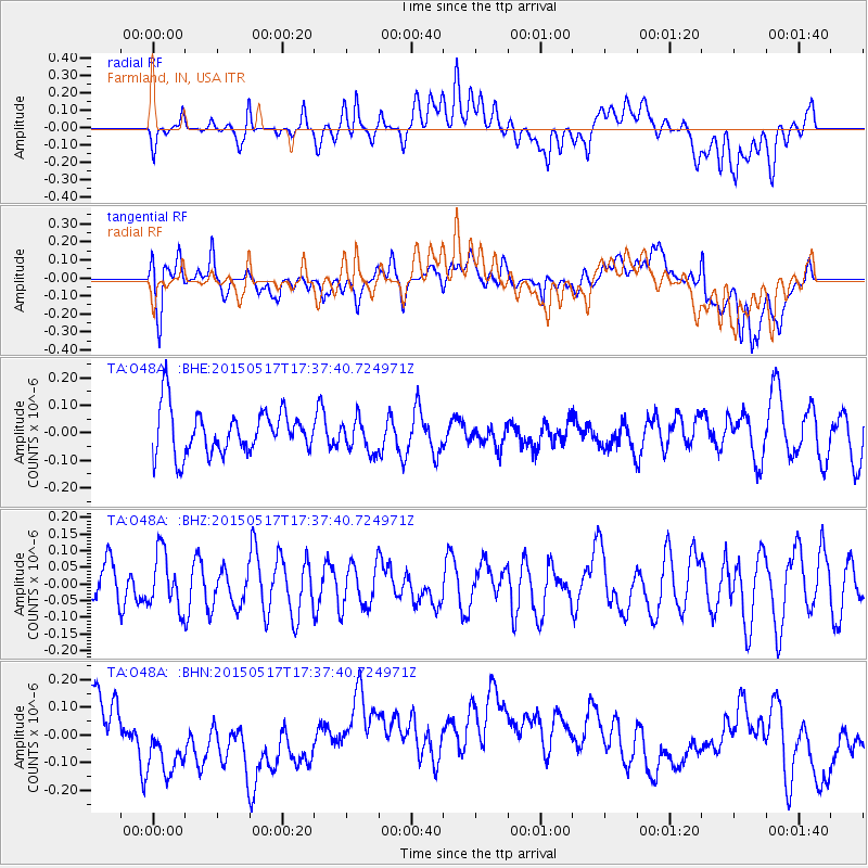
O48A Farmland, IN, USA - Earthquake Result Viewer
*The percent match for this event was below the threshold and hence no stack was calculated.
| Earthquake location: |
Kuril Islands |
| Earthquake latitude/longitude: |
44.5/146.5 |
| Earthquake time(UTC): |
2015/05/17 (137) 17:26:02 GMT |
| Earthquake Depth: |
168 km |
| Earthquake Magnitude: |
3.6 mb |
| Earthquake Catalog/Contributor: |
ISC/ISC |
|
| Network: |
TA USArray Transportable Network (new EarthScope stations) |
| Station: |
O48A Farmland, IN, USA |
| Lat/Lon: |
40.26 N/85.16 W |
| Elevation: |
300 m |
|
| Distance: |
83.7 deg |
| Az: |
37.155 deg |
| Baz: |
325.641 deg |
| Ray Param: |
$rayparam |
*The percent match for this event was below the threshold and hence was not used in the summary stack. |
|
| Radial Match: |
31.934498 % |
| Radial Bump: |
400 |
| Transverse Match: |
37.357315 % |
| Transverse Bump: |
400 |
| SOD ConfigId: |
7422571 |
| Insert Time: |
2019-04-18 22:40:32.528 +0000 |
| GWidth: |
2.5 |
| Max Bumps: |
400 |
| Tol: |
0.001 |
|
Signal To Noise
| Channel | StoN | STA | LTA |
| TA:O48A: :BHZ:20150517T17:37:40.724971Z | 1.140472 | 8.3584E-8 | 7.328895E-8 |
| TA:O48A: :BHN:20150517T17:37:40.724971Z | 1.3471116 | 1.5049895E-7 | 1.1171973E-7 |
| TA:O48A: :BHE:20150517T17:37:40.724971Z | 0.7516484 | 6.050736E-8 | 8.049955E-8 |
| Arrivals |
| Ps | |
| PpPs | |
| PsPs/PpSs | |


