You are here: Home > Network List > IU - Global Seismograph Network (GSN - IRIS/USGS) Stations List
> Station TIXI Tiksi, Russia > Earthquake Result Viewer
TIXI Tiksi, Russia - Earthquake Result Viewer
| Earthquake location: |
Solomon Islands |
| Earthquake latitude/longitude: |
-9.6/159.5 |
| Earthquake time(UTC): |
2001/12/23 (357) 22:52:54 GMT |
| Earthquake Depth: |
16 km |
| Earthquake Magnitude: |
6.2 MB, 7.0 MS, 6.8 MW, 6.7 MW |
| Earthquake Catalog/Contributor: |
WHDF/NEIC |
|
| Network: |
IU Global Seismograph Network (GSN - IRIS/USGS) |
| Station: |
TIXI Tiksi, Russia |
| Lat/Lon: |
71.65 N/128.87 E |
| Elevation: |
50 m |
|
| Distance: |
83.6 deg |
| Az: |
350.645 deg |
| Baz: |
149.597 deg |
| Ray Param: |
0.04605607 |
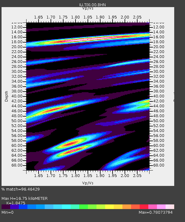
| Estimated Moho Depth: |
16.75 km |
| Estimated Crust Vp/Vs: |
1.85 |
| Assumed Crust Vp: |
6.552 km/s |
| Estimated Crust Vs: |
3.547 km/s |
| Estimated Crust Poisson's Ratio: |
0.29 |
|
| Radial Match: |
96.46429 % |
| Radial Bump: |
400 |
| Transverse Match: |
90.39507 % |
| Transverse Bump: |
400 |
| SOD ConfigId: |
20082 |
| Insert Time: |
2010-03-02 14:59:26.986 +0000 |
| GWidth: |
2.5 |
| Max Bumps: |
400 |
| Tol: |
0.001 |
|
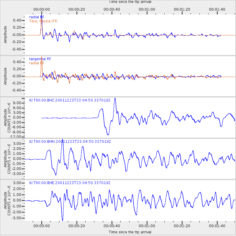
Signal To Noise
| Channel | StoN | STA | LTA |
| IU:TIXI:00:BHN:20011223T23:04:50.337019Z | 18.004522 | 1.0575849E-6 | 5.873996E-8 |
| IU:TIXI:00:BHE:20011223T23:04:50.337019Z | 5.081022 | 5.0388167E-7 | 9.9169355E-8 |
| IU:TIXI:00:BHZ:20011223T23:04:50.337019Z | 39.266262 | 3.1394916E-6 | 7.995393E-8 |
| Arrivals |
| Ps | 2.2 SECOND |
| PpPs | 7.1 SECOND |
| PsPs/PpSs | 9.3 SECOND |


