You are here: Home > Network List > TA - USArray Transportable Network (new EarthScope stations) Stations List
> Station A21K Barrow, AK, USA > Earthquake Result Viewer
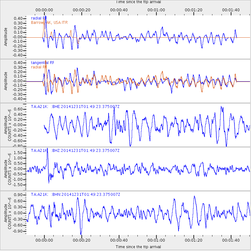
A21K Barrow, AK, USA - Earthquake Result Viewer
*The percent match for this event was below the threshold and hence no stack was calculated.
| Earthquake location: |
Near N Coast Of New Guinea, P.N.G. |
| Earthquake latitude/longitude: |
-4.4/144.0 |
| Earthquake time(UTC): |
2014/12/31 (365) 01:37:33 GMT |
| Earthquake Depth: |
123 km |
| Earthquake Magnitude: |
5.8 MWW, 5.8 MWC, 5.8 MWB |
| Earthquake Catalog/Contributor: |
NEIC PDE/NEIC COMCAT |
|
| Network: |
TA USArray Transportable Network (new EarthScope stations) |
| Station: |
A21K Barrow, AK, USA |
| Lat/Lon: |
71.32 N/156.62 W |
| Elevation: |
577 m |
|
| Distance: |
84.8 deg |
| Az: |
16.165 deg |
| Baz: |
239.495 deg |
| Ray Param: |
$rayparam |
*The percent match for this event was below the threshold and hence was not used in the summary stack. |
|
| Radial Match: |
66.570885 % |
| Radial Bump: |
400 |
| Transverse Match: |
66.68918 % |
| Transverse Bump: |
400 |
| SOD ConfigId: |
827991 |
| Insert Time: |
2015-01-20 19:43:43.325 +0000 |
| GWidth: |
2.5 |
| Max Bumps: |
400 |
| Tol: |
0.001 |
|
Signal To Noise
| Channel | StoN | STA | LTA |
| TA:A21K: :BHZ:20141231T01:49:23.375007Z | 3.6036563 | 7.4768104E-7 | 2.0747845E-7 |
| TA:A21K: :BHN:20141231T01:49:23.375007Z | 0.958594 | 2.8951322E-7 | 3.020186E-7 |
| TA:A21K: :BHE:20141231T01:49:23.375007Z | 0.63051766 | 1.5382989E-7 | 2.4397394E-7 |
| Arrivals |
| Ps | |
| PpPs | |
| PsPs/PpSs | |


