You are here: Home > Network List > IU - Global Seismograph Network (GSN - IRIS/USGS) Stations List
> Station TIXI Tiksi, Russia > Earthquake Result Viewer
TIXI Tiksi, Russia - Earthquake Result Viewer
| Earthquake location: |
Banda Sea |
| Earthquake latitude/longitude: |
-4.1/123.9 |
| Earthquake time(UTC): |
2001/10/19 (292) 03:28:44 GMT |
| Earthquake Depth: |
33 km |
| Earthquake Magnitude: |
6.3 MB, 7.3 MS, 7.5 MW, 7.4 MW |
| Earthquake Catalog/Contributor: |
WHDF/NEIC |
|
| Network: |
IU Global Seismograph Network (GSN - IRIS/USGS) |
| Station: |
TIXI Tiksi, Russia |
| Lat/Lon: |
71.65 N/128.87 E |
| Elevation: |
50 m |
|
| Distance: |
75.7 deg |
| Az: |
1.619 deg |
| Baz: |
185.106 deg |
| Ray Param: |
0.051459346 |
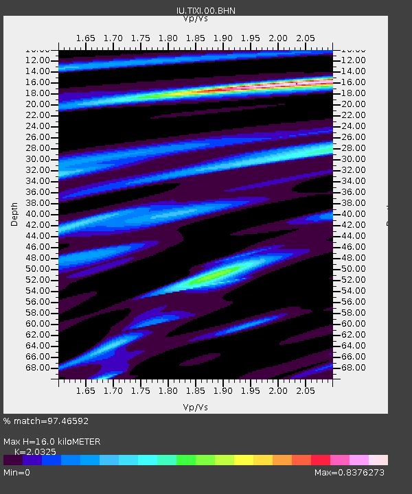
| Estimated Moho Depth: |
16.0 km |
| Estimated Crust Vp/Vs: |
2.03 |
| Assumed Crust Vp: |
6.552 km/s |
| Estimated Crust Vs: |
3.224 km/s |
| Estimated Crust Poisson's Ratio: |
0.34 |
|
| Radial Match: |
97.46592 % |
| Radial Bump: |
384 |
| Transverse Match: |
91.766525 % |
| Transverse Bump: |
400 |
| SOD ConfigId: |
20082 |
| Insert Time: |
2010-03-02 14:59:50.760 +0000 |
| GWidth: |
2.5 |
| Max Bumps: |
400 |
| Tol: |
0.001 |
|

Signal To Noise
| Channel | StoN | STA | LTA |
| IU:TIXI:00:BHN:20011019T03:39:55.433022Z | 3.3719625 | 4.4105974E-7 | 1.3080209E-7 |
| IU:TIXI:00:BHE:20011019T03:39:55.433022Z | 0.96858203 | 1.7454381E-7 | 1.802055E-7 |
| IU:TIXI:00:BHZ:20011019T03:39:55.433022Z | 5.24515 | 1.2477067E-6 | 2.3787817E-7 |
| Arrivals |
| Ps | 2.6 SECOND |
| PpPs | 7.2 SECOND |
| PsPs/PpSs | 9.8 SECOND |


