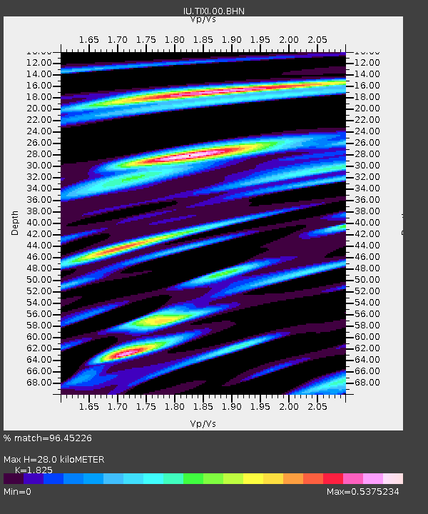
TIXI Tiksi, Russia - Earthquake Result Viewer
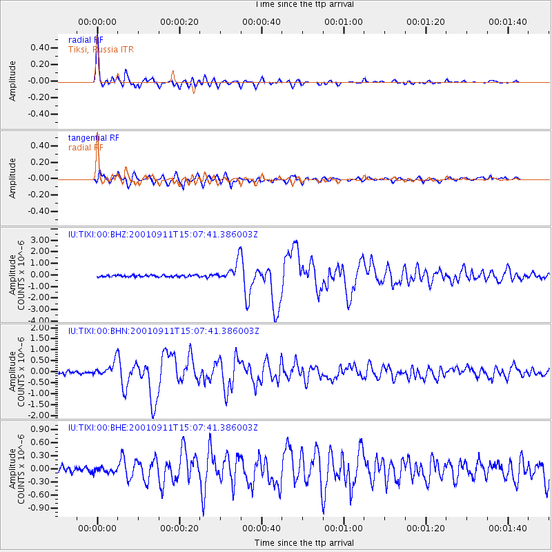
Earthquake location: Irian Jaya Region, Indonesia
Earthquake latitude/longitude: -0.6/133.1
Earthquake time(UTC): 2001/09/11 (254) 14:56:50 GMT
Earthquake Depth: 33 km
Earthquake Magnitude: 5.8 MB, 6.4 MS, 6.6 MW, 6.5 MW
Earthquake Catalog/Contributor: WHDF/NEIC
Network: IU Global Seismograph Network (GSN - IRIS/USGS)
Station: TIXI Tiksi, Russia
Lat/Lon: 71.65 N/128.87 E
Elevation: 50 m
Distance: 72.2 deg
Az: 358.583 deg
Baz: 175.521 deg
Ray Param: 0.053796027
Estimated Moho Depth: 28.0 km
Estimated Crust Vp/Vs: 1.83
Assumed Crust Vp: 6.552 km/s
Estimated Crust Vs: 3.59 km/s
Estimated Crust Poisson's Ratio: 0.29
Radial Match: 96.45226 %
Radial Bump: 400
Transverse Match: 92.0141 %
Transverse Bump: 400
SOD ConfigId: 20082
Insert Time: 2010-03-02 14:59:59.143 +0000
GWidth: 2.5
Max Bumps: 400
Tol: 0.001

Signal To Noise

ChannelStoNSTALTA
IU:TIXI:00:BHN:20010911T15:07:41.386003Z6.79873.6386004E-75.3519063E-8
IU:TIXI:00:BHE:20010911T15:07:41.386003Z0.931372945.5809398E-85.992164E-8
IU:TIXI:00:BHZ:20010911T15:07:41.386003Z12.3894248.7881745E-77.093287E-8
Arrivals
Ps3.7 SECOND
PpPs12 SECOND
PsPs/PpSs15 SECOND