You are here: Home > Network List > UW - Pacific Northwest Regional Seismic Network Stations List
> Station LEBA Lebam, WA, USA > Earthquake Result Viewer
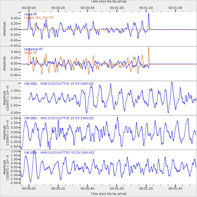
LEBA Lebam, WA, USA - Earthquake Result Viewer
*The percent match for this event was below the threshold and hence no stack was calculated.
| Earthquake location: |
South Of Panama |
| Earthquake latitude/longitude: |
5.8/-82.7 |
| Earthquake time(UTC): |
2015/01/07 (007) 05:07:08 GMT |
| Earthquake Depth: |
10 km |
| Earthquake Magnitude: |
6.6 MWP, 6.6 MI |
| Earthquake Catalog/Contributor: |
NEIC PDE/NEIC COMCAT |
|
| Network: |
UW Pacific Northwest Regional Seismic Network |
| Station: |
LEBA Lebam, WA, USA |
| Lat/Lon: |
46.55 N/123.56 W |
| Elevation: |
73 m |
|
| Distance: |
53.7 deg |
| Az: |
325.888 deg |
| Baz: |
126.062 deg |
| Ray Param: |
$rayparam |
*The percent match for this event was below the threshold and hence was not used in the summary stack. |
|
| Radial Match: |
68.67653 % |
| Radial Bump: |
400 |
| Transverse Match: |
53.889557 % |
| Transverse Bump: |
400 |
| SOD ConfigId: |
827991 |
| Insert Time: |
2015-01-21 05:51:06.813 +0000 |
| GWidth: |
2.5 |
| Max Bumps: |
400 |
| Tol: |
0.001 |
|
Signal To Noise
| Channel | StoN | STA | LTA |
| UW:LEBA: :HHZ:20150107T05:15:59.398018Z | 0.7433072 | 6.103512E-7 | 8.2112916E-7 |
| UW:LEBA: :HHN:20150107T05:15:59.398018Z | 2.1795812 | 1.3424911E-6 | 6.1593994E-7 |
| UW:LEBA: :HHE:20150107T05:15:59.398018Z | 1.3686433 | 5.0962893E-7 | 3.7236066E-7 |
| Arrivals |
| Ps | |
| PpPs | |
| PsPs/PpSs | |


