You are here: Home > Network List > IU - Global Seismograph Network (GSN - IRIS/USGS) Stations List
> Station TIXI Tiksi, Russia > Earthquake Result Viewer
TIXI Tiksi, Russia - Earthquake Result Viewer
| Earthquake location: |
Northern Molucca Sea |
| Earthquake latitude/longitude: |
2.8/127.0 |
| Earthquake time(UTC): |
2001/08/04 (216) 01:44:53 GMT |
| Earthquake Depth: |
33 km |
| Earthquake Magnitude: |
5.8 MB, 5.6 MS, 5.8 MW, 5.8 MW |
| Earthquake Catalog/Contributor: |
WHDF/NEIC |
|
| Network: |
IU Global Seismograph Network (GSN - IRIS/USGS) |
| Station: |
TIXI Tiksi, Russia |
| Lat/Lon: |
71.65 N/128.87 E |
| Elevation: |
50 m |
|
| Distance: |
68.8 deg |
| Az: |
0.636 deg |
| Baz: |
182.006 deg |
| Ray Param: |
0.05604668 |
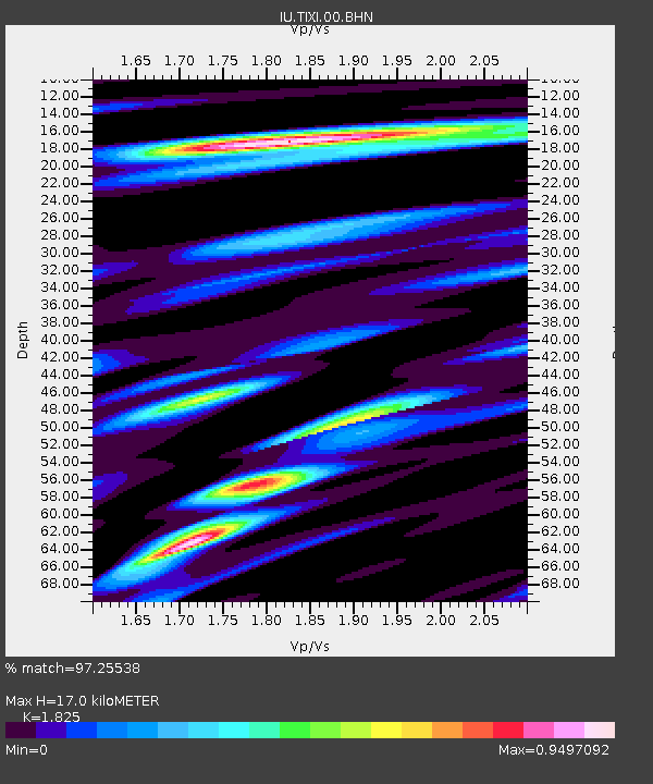
| Estimated Moho Depth: |
17.0 km |
| Estimated Crust Vp/Vs: |
1.83 |
| Assumed Crust Vp: |
6.552 km/s |
| Estimated Crust Vs: |
3.59 km/s |
| Estimated Crust Poisson's Ratio: |
0.29 |
|
| Radial Match: |
97.25538 % |
| Radial Bump: |
376 |
| Transverse Match: |
95.796844 % |
| Transverse Bump: |
400 |
| SOD ConfigId: |
20082 |
| Insert Time: |
2010-03-02 15:00:18.139 +0000 |
| GWidth: |
2.5 |
| Max Bumps: |
400 |
| Tol: |
0.001 |
|

Signal To Noise
| Channel | StoN | STA | LTA |
| IU:TIXI:00:BHN:20010804T01:55:23.434009Z | 15.427898 | 3.505063E-7 | 2.2718991E-8 |
| IU:TIXI:00:BHE:20010804T01:55:23.434009Z | 2.7661967 | 8.4375394E-8 | 3.0502314E-8 |
| IU:TIXI:00:BHZ:20010804T01:55:23.434009Z | 19.558432 | 8.8902937E-7 | 4.5455046E-8 |
| Arrivals |
| Ps | 2.2 SECOND |
| PpPs | 7.1 SECOND |
| PsPs/PpSs | 9.3 SECOND |


