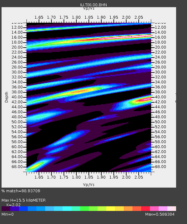
TIXI Tiksi, Russia - Earthquake Result Viewer
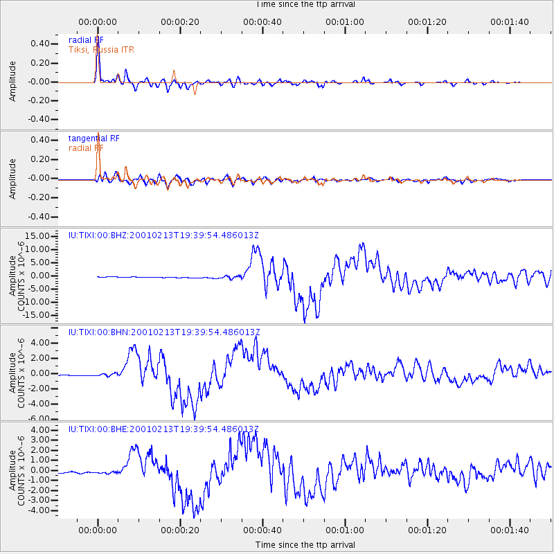
Earthquake location: Southern Sumatra, Indonesia
Earthquake latitude/longitude: -4.7/102.6
Earthquake time(UTC): 2001/02/13 (044) 19:28:30 GMT
Earthquake Depth: 36 km
Earthquake Magnitude: 6.2 MB, 7.2 MS, 7.4 MW, 7.0 ME
Earthquake Catalog/Contributor: WHDF/NEIC
Network: IU Global Seismograph Network (GSN - IRIS/USGS)
Station: TIXI Tiksi, Russia
Lat/Lon: 71.65 N/128.87 E
Elevation: 50 m
Distance: 78.1 deg
Az: 8.247 deg
Baz: 206.832 deg
Ray Param: 0.04981613
Estimated Moho Depth: 15.5 km
Estimated Crust Vp/Vs: 2.02
Assumed Crust Vp: 6.552 km/s
Estimated Crust Vs: 3.244 km/s
Estimated Crust Poisson's Ratio: 0.34
Radial Match: 98.93709 %
Radial Bump: 313
Transverse Match: 93.09774 %
Transverse Bump: 400
SOD ConfigId: 3744
Insert Time: 2010-03-02 15:00:58.382 +0000
GWidth: 2.5
Max Bumps: 400
Tol: 0.001

Signal To Noise

ChannelStoNSTALTA
IU:TIXI:00:BHN:20010213T19:39:54.486013Z1.6287371.5081028E-79.259339E-8
IU:TIXI:00:BHE:20010213T19:39:54.486013Z1.49880398.447988E-85.636487E-8
IU:TIXI:00:BHZ:20010213T19:39:54.486013Z3.40354064.889102E-71.4364753E-7
Arrivals
Ps2.5 SECOND
PpPs7.0 SECOND
PsPs/PpSs9.4 SECOND