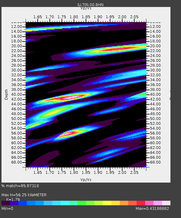
TIXI Tiksi, Russia - Earthquake Result Viewer
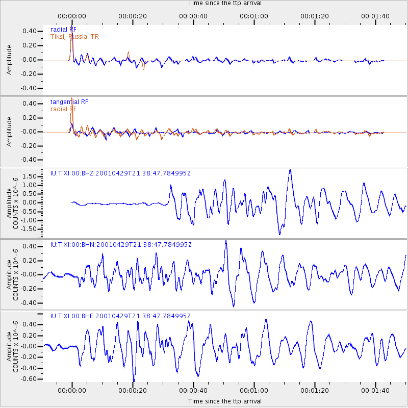
Earthquake location: Near Coast Of Jalisco, Mexico
Earthquake latitude/longitude: 18.7/-104.5
Earthquake time(UTC): 2001/04/29 (119) 21:26:54 GMT
Earthquake Depth: 10 km
Earthquake Magnitude: 5.2 MB, 5.5 MS, 6.1 MW, 6.1 MW
Earthquake Catalog/Contributor: WHDF/NEIC
Network: IU Global Seismograph Network (GSN - IRIS/USGS)
Station: TIXI Tiksi, Russia
Lat/Lon: 71.65 N/128.87 E
Elevation: 50 m
Distance: 82.9 deg
Az: 345.149 deg
Baz: 50.069 deg
Ray Param: 0.04657901
Estimated Moho Depth: 56.25 km
Estimated Crust Vp/Vs: 1.76
Assumed Crust Vp: 6.552 km/s
Estimated Crust Vs: 3.723 km/s
Estimated Crust Poisson's Ratio: 0.26
Radial Match: 95.97318 %
Radial Bump: 390
Transverse Match: 94.24482 %
Transverse Bump: 392
SOD ConfigId: 4714
Insert Time: 2010-03-02 15:01:41.531 +0000
GWidth: 2.5
Max Bumps: 400
Tol: 0.001

Signal To Noise

ChannelStoNSTALTA
IU:TIXI:00:BHN:20010429T21:38:47.784995Z2.0472367.052083E-83.444685E-8
IU:TIXI:00:BHE:20010429T21:38:47.784995Z5.70502761.4583333E-72.5562247E-8
IU:TIXI:00:BHZ:20010429T21:38:47.784995Z10.6546884.2754777E-74.0127667E-8
Arrivals
Ps6.7 SECOND
PpPs23 SECOND
PsPs/PpSs30 SECOND