You are here: Home > Network List > TA - USArray Transportable Network (new EarthScope stations) Stations List
> Station R11A Troy Canyon, Currant, NV, USA > Earthquake Result Viewer
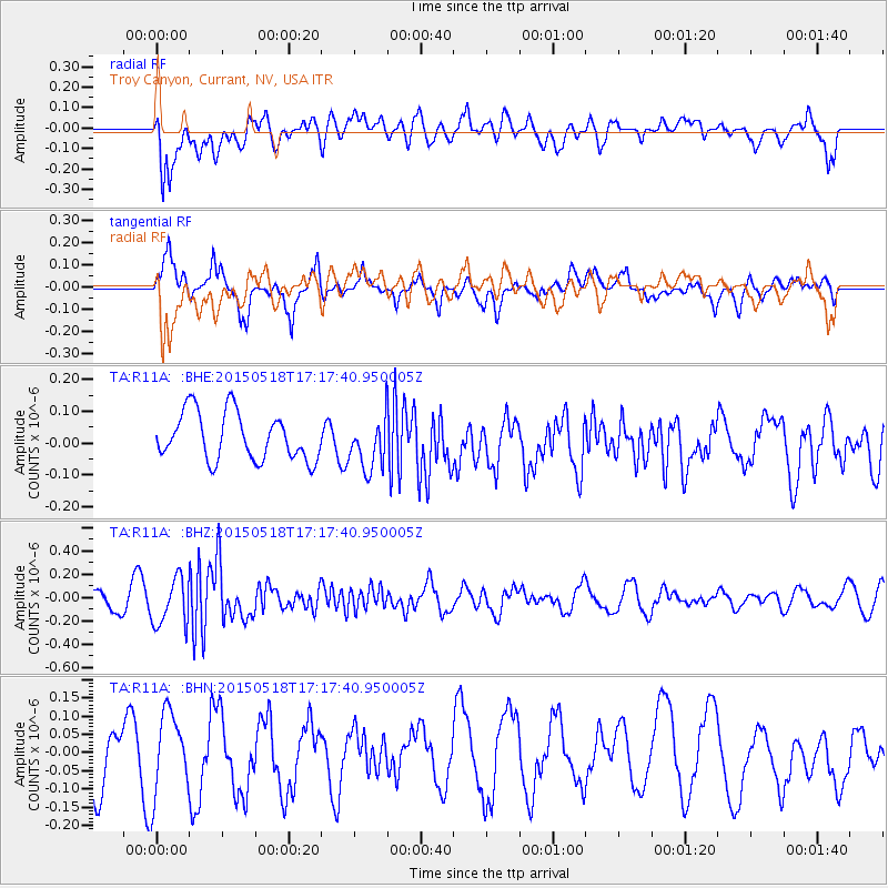
R11A Troy Canyon, Currant, NV, USA - Earthquake Result Viewer
*The percent match for this event was below the threshold and hence no stack was calculated.
| Earthquake location: |
Solomon Islands |
| Earthquake latitude/longitude: |
-7.2/154.4 |
| Earthquake time(UTC): |
2015/05/18 (138) 17:04:52 GMT |
| Earthquake Depth: |
10 km |
| Earthquake Magnitude: |
5.7 MWC, 5.6 MWB, 5.7 MWC |
| Earthquake Catalog/Contributor: |
NEIC PDE/NEIC COMCAT |
|
| Network: |
TA USArray Transportable Network (new EarthScope stations) |
| Station: |
R11A Troy Canyon, Currant, NV, USA |
| Lat/Lon: |
38.35 N/115.59 W |
| Elevation: |
1756 m |
|
| Distance: |
94.4 deg |
| Az: |
52.052 deg |
| Baz: |
264.365 deg |
| Ray Param: |
$rayparam |
*The percent match for this event was below the threshold and hence was not used in the summary stack. |
|
| Radial Match: |
55.258907 % |
| Radial Bump: |
400 |
| Transverse Match: |
65.28275 % |
| Transverse Bump: |
400 |
| SOD ConfigId: |
7422571 |
| Insert Time: |
2019-04-18 23:01:22.505 +0000 |
| GWidth: |
2.5 |
| Max Bumps: |
400 |
| Tol: |
0.001 |
|
Signal To Noise
| Channel | StoN | STA | LTA |
| TA:R11A: :BHZ:20150518T17:17:40.950005Z | 2.5257738 | 2.0407627E-7 | 8.079753E-8 |
| TA:R11A: :BHN:20150518T17:17:40.950005Z | 1.7108095 | 1.0929021E-7 | 6.388217E-8 |
| TA:R11A: :BHE:20150518T17:17:40.950005Z | 1.0123142 | 7.5617336E-8 | 7.4697496E-8 |
| Arrivals |
| Ps | |
| PpPs | |
| PsPs/PpSs | |


