You are here: Home > Network List > CI - Caltech Regional Seismic Network Stations List
> Station MPM Manuel Prospect Mine, California, USA > Earthquake Result Viewer
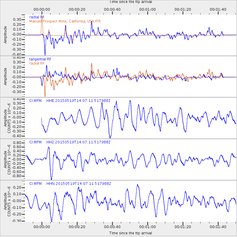
MPM Manuel Prospect Mine, California, USA - Earthquake Result Viewer
*The percent match for this event was below the threshold and hence no stack was calculated.
| Earthquake location: |
Vanuatu Islands |
| Earthquake latitude/longitude: |
-18.6/168.6 |
| Earthquake time(UTC): |
2015/05/19 (139) 13:54:55 GMT |
| Earthquake Depth: |
50 km |
| Earthquake Magnitude: |
5.8 MWB, 5.9 MWC |
| Earthquake Catalog/Contributor: |
NEIC PDE/NEIC COMCAT |
|
| Network: |
CI Caltech Regional Seismic Network |
| Station: |
MPM Manuel Prospect Mine, California, USA |
| Lat/Lon: |
36.06 N/117.49 W |
| Elevation: |
185 m |
|
| Distance: |
88.5 deg |
| Az: |
51.168 deg |
| Baz: |
245.742 deg |
| Ray Param: |
$rayparam |
*The percent match for this event was below the threshold and hence was not used in the summary stack. |
|
| Radial Match: |
70.08685 % |
| Radial Bump: |
400 |
| Transverse Match: |
57.598843 % |
| Transverse Bump: |
400 |
| SOD ConfigId: |
7422571 |
| Insert Time: |
2019-04-18 23:10:32.783 +0000 |
| GWidth: |
2.5 |
| Max Bumps: |
400 |
| Tol: |
0.001 |
|
Signal To Noise
| Channel | StoN | STA | LTA |
| CI:MPM: :HHZ:20150519T14:07:11.517988Z | 1.6430124 | 2.8060023E-7 | 1.70784E-7 |
| CI:MPM: :HHN:20150519T14:07:11.517988Z | 0.74062073 | 8.803124E-8 | 1.18861436E-7 |
| CI:MPM: :HHE:20150519T14:07:11.517988Z | 1.6153016 | 1.7869634E-7 | 1.10627234E-7 |
| Arrivals |
| Ps | |
| PpPs | |
| PsPs/PpSs | |


