You are here: Home > Network List > AK - Alaska Regional Network Stations List
> Station CUT Chulitna, AK, USA > Earthquake Result Viewer
CUT Chulitna, AK, USA - Earthquake Result Viewer

| Earthquake location: |
Tonga Islands |
| Earthquake latitude/longitude: |
-19.3/-175.5 |
| Earthquake time(UTC): |
2015/05/20 (140) 00:30:51 GMT |
| Earthquake Depth: |
180 km |
| Earthquake Magnitude: |
6.0 MWP |
| Earthquake Catalog/Contributor: |
NEIC PDE/NEIC COMCAT |
|
| Network: |
AK Alaska Regional Network |
| Station: |
CUT Chulitna, AK, USA |
| Lat/Lon: |
62.41 N/150.26 W |
| Elevation: |
574 m |
|
| Distance: |
83.8 deg |
| Az: |
11.502 deg |
| Baz: |
203.856 deg |
| Ray Param: |
0.04547371 |
| Estimated Moho Depth: |
69.25 km |
| Estimated Crust Vp/Vs: |
1.79 |
| Assumed Crust Vp: |
6.438 km/s |
| Estimated Crust Vs: |
3.602 km/s |
| Estimated Crust Poisson's Ratio: |
0.27 |
|
| Radial Match: |
81.19916 % |
| Radial Bump: |
393 |
| Transverse Match: |
70.65258 % |
| Transverse Bump: |
400 |
| SOD ConfigId: |
7422571 |
| Insert Time: |
2019-04-18 23:21:34.249 +0000 |
| GWidth: |
2.5 |
| Max Bumps: |
400 |
| Tol: |
0.001 |
|
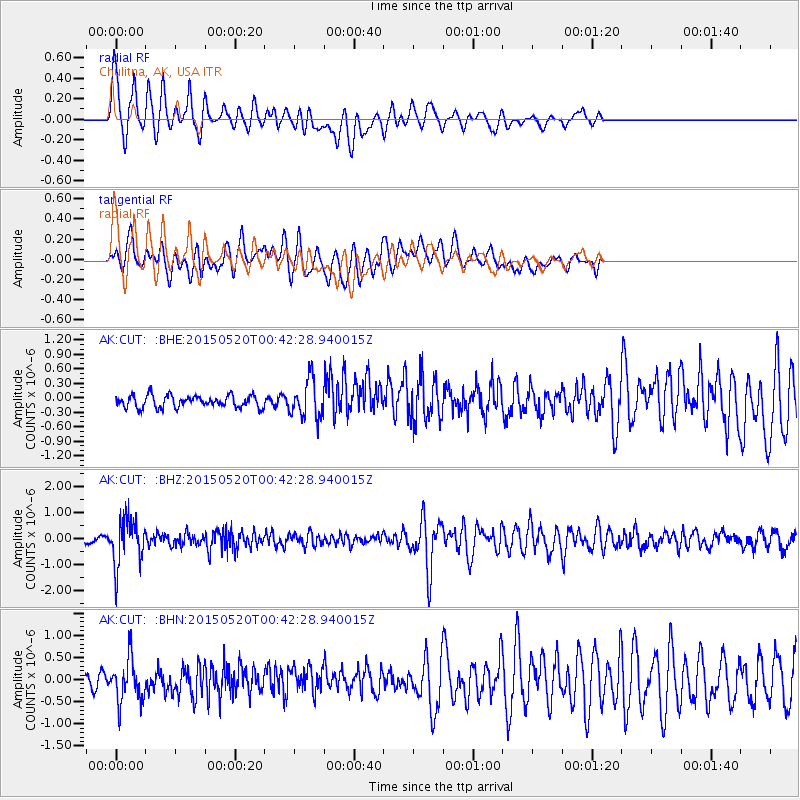
Signal To Noise
| Channel | StoN | STA | LTA |
| AK:CUT: :BHZ:20150520T00:42:28.940015Z | 10.644131 | 8.8658453E-7 | 8.329328E-8 |
| AK:CUT: :BHN:20150520T00:42:28.940015Z | 3.933146 | 4.975546E-7 | 1.2650295E-7 |
| AK:CUT: :BHE:20150520T00:42:28.940015Z | 3.4492478 | 4.3113477E-7 | 1.2499385E-7 |
| Arrivals |
| Ps | 8.7 SECOND |
| PpPs | 29 SECOND |
| PsPs/PpSs | 38 SECOND |


