You are here: Home > Network List > CI - Caltech Regional Seismic Network Stations List
> Station DGR Domenigoni Reservoir, California, USA > Earthquake Result Viewer
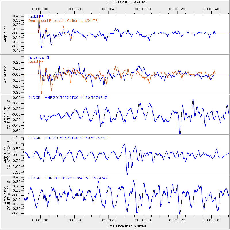
DGR Domenigoni Reservoir, California, USA - Earthquake Result Viewer
*The percent match for this event was below the threshold and hence no stack was calculated.
| Earthquake location: |
Tonga Islands |
| Earthquake latitude/longitude: |
-19.3/-175.5 |
| Earthquake time(UTC): |
2015/05/20 (140) 00:30:51 GMT |
| Earthquake Depth: |
180 km |
| Earthquake Magnitude: |
6.0 MWP |
| Earthquake Catalog/Contributor: |
NEIC PDE/NEIC COMCAT |
|
| Network: |
CI Caltech Regional Seismic Network |
| Station: |
DGR Domenigoni Reservoir, California, USA |
| Lat/Lon: |
33.65 N/117.01 W |
| Elevation: |
609 m |
|
| Distance: |
76.6 deg |
| Az: |
46.938 deg |
| Baz: |
235.817 deg |
| Ray Param: |
$rayparam |
*The percent match for this event was below the threshold and hence was not used in the summary stack. |
|
| Radial Match: |
71.52226 % |
| Radial Bump: |
400 |
| Transverse Match: |
64.05831 % |
| Transverse Bump: |
400 |
| SOD ConfigId: |
7422571 |
| Insert Time: |
2019-04-18 23:23:45.147 +0000 |
| GWidth: |
2.5 |
| Max Bumps: |
400 |
| Tol: |
0.001 |
|
Signal To Noise
| Channel | StoN | STA | LTA |
| CI:DGR: :HHZ:20150520T00:41:50.597974Z | 2.7051892 | 3.5801335E-7 | 1.3234319E-7 |
| CI:DGR: :HHN:20150520T00:41:50.597974Z | 0.8066374 | 1.0149713E-7 | 1.2582746E-7 |
| CI:DGR: :HHE:20150520T00:41:50.597974Z | 2.1894248 | 2.0295336E-7 | 9.2697114E-8 |
| Arrivals |
| Ps | |
| PpPs | |
| PsPs/PpSs | |


