You are here: Home > Network List > CN - Canadian National Seismograph Network Stations List
> Station INK INUVIK, NT > Earthquake Result Viewer
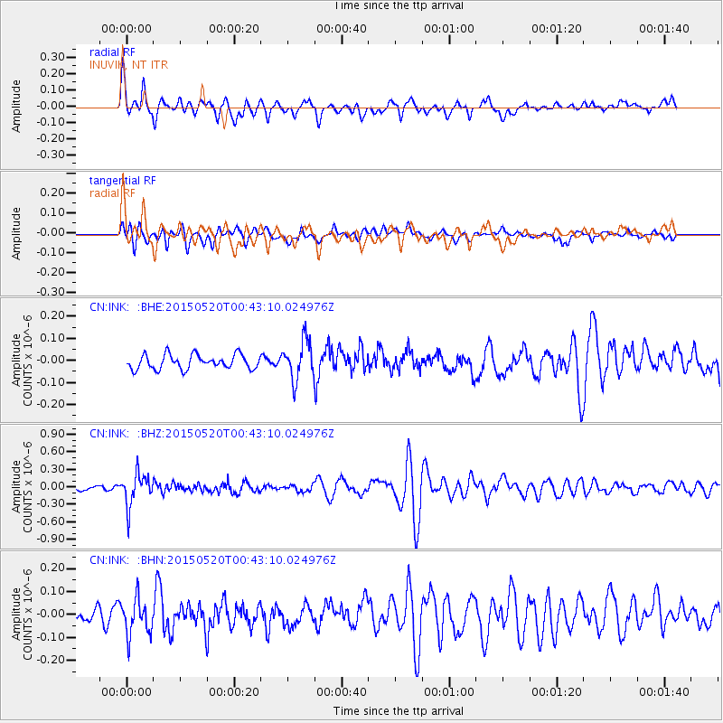
INK INUVIK, NT - Earthquake Result Viewer
*The percent match for this event was below the threshold and hence no stack was calculated.
| Earthquake location: |
Tonga Islands |
| Earthquake latitude/longitude: |
-19.3/-175.5 |
| Earthquake time(UTC): |
2015/05/20 (140) 00:30:51 GMT |
| Earthquake Depth: |
180 km |
| Earthquake Magnitude: |
6.0 MWP |
| Earthquake Catalog/Contributor: |
NEIC PDE/NEIC COMCAT |
|
| Network: |
CN Canadian National Seismograph Network |
| Station: |
INK INUVIK, NT |
| Lat/Lon: |
68.31 N/133.53 W |
| Elevation: |
44 m |
|
| Distance: |
92.5 deg |
| Az: |
14.401 deg |
| Baz: |
219.182 deg |
| Ray Param: |
$rayparam |
*The percent match for this event was below the threshold and hence was not used in the summary stack. |
|
| Radial Match: |
78.37215 % |
| Radial Bump: |
400 |
| Transverse Match: |
41.42708 % |
| Transverse Bump: |
400 |
| SOD ConfigId: |
7422571 |
| Insert Time: |
2019-04-18 23:24:16.912 +0000 |
| GWidth: |
2.5 |
| Max Bumps: |
400 |
| Tol: |
0.001 |
|
Signal To Noise
| Channel | StoN | STA | LTA |
| CN:INK: :BHZ:20150520T00:43:10.024976Z | 4.553639 | 2.7916465E-7 | 6.130584E-8 |
| CN:INK: :BHN:20150520T00:43:10.024976Z | 2.5751214 | 7.851854E-8 | 3.0491197E-8 |
| CN:INK: :BHE:20150520T00:43:10.024976Z | 3.092681 | 1.0180264E-7 | 3.2917278E-8 |
| Arrivals |
| Ps | |
| PpPs | |
| PsPs/PpSs | |


