You are here: Home > Network List > TA - USArray Transportable Network (new EarthScope stations) Stations List
> Station G03D McMinnville, OR, USA > Earthquake Result Viewer
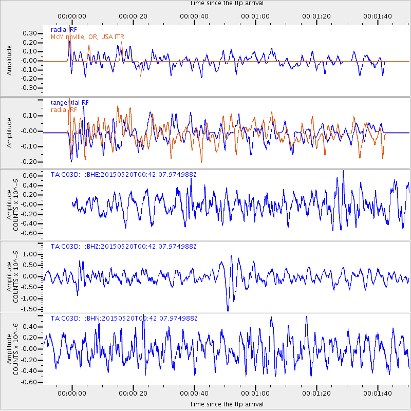
G03D McMinnville, OR, USA - Earthquake Result Viewer
*The percent match for this event was below the threshold and hence no stack was calculated.
| Earthquake location: |
Tonga Islands |
| Earthquake latitude/longitude: |
-19.3/-175.5 |
| Earthquake time(UTC): |
2015/05/20 (140) 00:30:51 GMT |
| Earthquake Depth: |
180 km |
| Earthquake Magnitude: |
6.0 MWP |
| Earthquake Catalog/Contributor: |
NEIC PDE/NEIC COMCAT |
|
| Network: |
TA USArray Transportable Network (new EarthScope stations) |
| Station: |
G03D McMinnville, OR, USA |
| Lat/Lon: |
45.21 N/123.26 W |
| Elevation: |
222 m |
|
| Distance: |
79.8 deg |
| Az: |
34.573 deg |
| Baz: |
229.305 deg |
| Ray Param: |
$rayparam |
*The percent match for this event was below the threshold and hence was not used in the summary stack. |
|
| Radial Match: |
46.07378 % |
| Radial Bump: |
400 |
| Transverse Match: |
53.668945 % |
| Transverse Bump: |
400 |
| SOD ConfigId: |
7422571 |
| Insert Time: |
2019-04-18 23:27:07.102 +0000 |
| GWidth: |
2.5 |
| Max Bumps: |
400 |
| Tol: |
0.001 |
|
Signal To Noise
| Channel | StoN | STA | LTA |
| TA:G03D: :BHZ:20150520T00:42:07.974988Z | 2.2595809 | 3.7285804E-7 | 1.6501204E-7 |
| TA:G03D: :BHN:20150520T00:42:07.974988Z | 0.8705823 | 1.4676102E-7 | 1.6857801E-7 |
| TA:G03D: :BHE:20150520T00:42:07.974988Z | 1.0189596 | 1.6901372E-7 | 1.6586891E-7 |
| Arrivals |
| Ps | |
| PpPs | |
| PsPs/PpSs | |


