You are here: Home > Network List > IU - Global Seismograph Network (GSN - IRIS/USGS) Stations List
> Station PMG Port Moresby, New Guinea > Earthquake Result Viewer
PMG Port Moresby, New Guinea - Earthquake Result Viewer
| Earthquake location: |
Hindu Kush Region, Afghanistan |
| Earthquake latitude/longitude: |
36.4/70.4 |
| Earthquake time(UTC): |
2002/03/03 (062) 12:08:07 GMT |
| Earthquake Depth: |
209 km |
| Earthquake Magnitude: |
6.3 MB |
| Earthquake Catalog/Contributor: |
WHDF/NEIC |
|
| Network: |
IU Global Seismograph Network (GSN - IRIS/USGS) |
| Station: |
PMG Port Moresby, New Guinea |
| Lat/Lon: |
9.41 S/147.15 E |
| Elevation: |
67 m |
|
| Distance: |
85.0 deg |
| Az: |
105.429 deg |
| Baz: |
308.011 deg |
| Ray Param: |
0.04456421 |
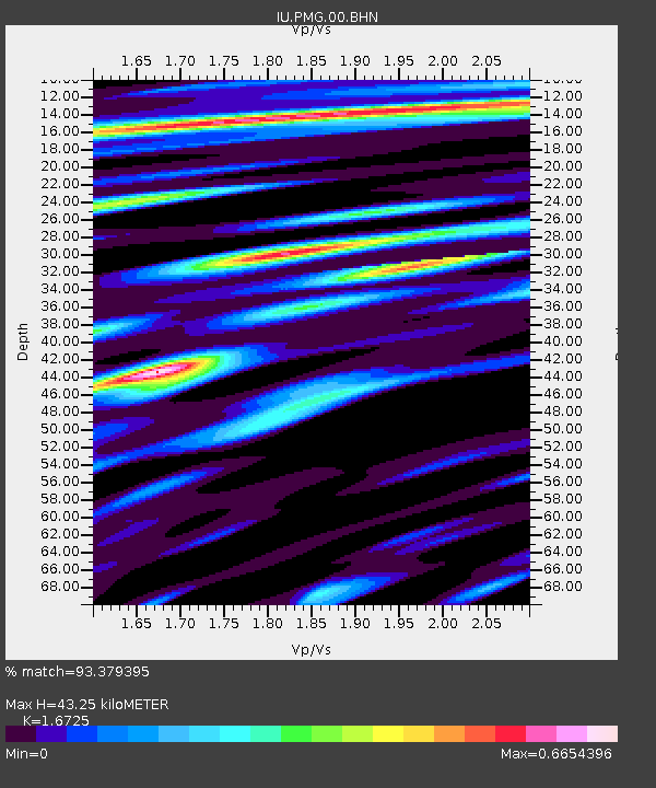
| Estimated Moho Depth: |
43.25 km |
| Estimated Crust Vp/Vs: |
1.67 |
| Assumed Crust Vp: |
6.122 km/s |
| Estimated Crust Vs: |
3.66 km/s |
| Estimated Crust Poisson's Ratio: |
0.22 |
|
| Radial Match: |
93.379395 % |
| Radial Bump: |
400 |
| Transverse Match: |
92.492386 % |
| Transverse Bump: |
357 |
| SOD ConfigId: |
20082 |
| Insert Time: |
2010-03-02 15:07:35.612 +0000 |
| GWidth: |
2.5 |
| Max Bumps: |
400 |
| Tol: |
0.001 |
|

Signal To Noise
| Channel | StoN | STA | LTA |
| IU:PMG:00:BHN:20020303T12:19:48.434023Z | 2.0811985 | 3.8095064E-7 | 1.8304388E-7 |
| IU:PMG:00:BHE:20020303T12:19:48.434023Z | 2.3525174 | 2.9729551E-7 | 1.2637335E-7 |
| IU:PMG:00:BHZ:20020303T12:19:48.434023Z | 3.9957323 | 8.321135E-7 | 2.0825055E-7 |
| Arrivals |
| Ps | 4.9 SECOND |
| PpPs | 18 SECOND |
| PsPs/PpSs | 23 SECOND |


