You are here: Home > Network List > UW - Pacific Northwest Regional Seismic Network Stations List
> Station LCCR Mulino, OR, USA > Earthquake Result Viewer
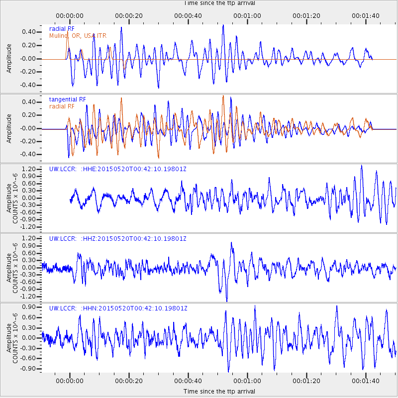
LCCR Mulino, OR, USA - Earthquake Result Viewer
*The percent match for this event was below the threshold and hence no stack was calculated.
| Earthquake location: |
Tonga Islands |
| Earthquake latitude/longitude: |
-19.3/-175.5 |
| Earthquake time(UTC): |
2015/05/20 (140) 00:30:51 GMT |
| Earthquake Depth: |
180 km |
| Earthquake Magnitude: |
6.0 MWP |
| Earthquake Catalog/Contributor: |
NEIC PDE/NEIC COMCAT |
|
| Network: |
UW Pacific Northwest Regional Seismic Network |
| Station: |
LCCR Mulino, OR, USA |
| Lat/Lon: |
45.21 N/122.48 W |
| Elevation: |
273 m |
|
| Distance: |
80.2 deg |
| Az: |
34.942 deg |
| Baz: |
229.925 deg |
| Ray Param: |
$rayparam |
*The percent match for this event was below the threshold and hence was not used in the summary stack. |
|
| Radial Match: |
73.13471 % |
| Radial Bump: |
400 |
| Transverse Match: |
62.6926 % |
| Transverse Bump: |
400 |
| SOD ConfigId: |
7422571 |
| Insert Time: |
2019-04-18 23:28:25.235 +0000 |
| GWidth: |
2.5 |
| Max Bumps: |
400 |
| Tol: |
0.001 |
|
Signal To Noise
| Channel | StoN | STA | LTA |
| UW:LCCR: :HHZ:20150520T00:42:10.19801Z | 3.5190058 | 3.487523E-7 | 9.910535E-8 |
| UW:LCCR: :HHN:20150520T00:42:10.19801Z | 1.9749973 | 2.6815158E-7 | 1.3577315E-7 |
| UW:LCCR: :HHE:20150520T00:42:10.19801Z | 1.3426152 | 2.8076198E-7 | 2.0911574E-7 |
| Arrivals |
| Ps | |
| PpPs | |
| PsPs/PpSs | |


