You are here: Home > Network List > XD14 - Illuminating the architecture of the greater Mount St. Helens magmatic systems f Stations List
> Station MH11 "Mount St Helens, WA" > Earthquake Result Viewer
MH11 "Mount St Helens, WA" - Earthquake Result Viewer
| Earthquake location: |
Tonga Islands |
| Earthquake latitude/longitude: |
-19.3/-175.5 |
| Earthquake time(UTC): |
2015/05/20 (140) 00:30:51 GMT |
| Earthquake Depth: |
180 km |
| Earthquake Magnitude: |
6.0 MWP |
| Earthquake Catalog/Contributor: |
NEIC PDE/NEIC COMCAT |
|
| Network: |
XD Illuminating the architecture of the greater Mount St. Helens magmatic systems f |
| Station: |
MH11 "Mount St Helens, WA" |
| Lat/Lon: |
46.27 N/121.58 W |
| Elevation: |
1447 m |
|
| Distance: |
81.4 deg |
| Az: |
34.522 deg |
| Baz: |
230.5 deg |
| Ray Param: |
0.047170017 |
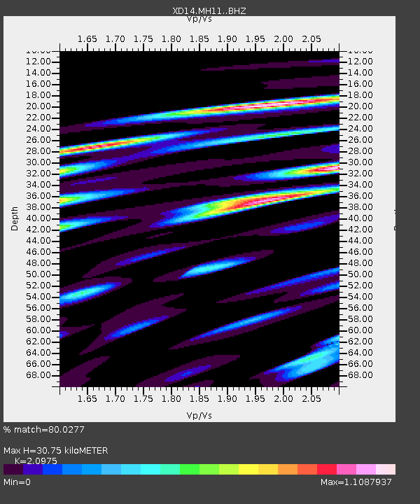
| Estimated Moho Depth: |
30.75 km |
| Estimated Crust Vp/Vs: |
2.10 |
| Assumed Crust Vp: |
6.597 km/s |
| Estimated Crust Vs: |
3.145 km/s |
| Estimated Crust Poisson's Ratio: |
0.35 |
|
| Radial Match: |
80.0277 % |
| Radial Bump: |
400 |
| Transverse Match: |
69.61936 % |
| Transverse Bump: |
400 |
| SOD ConfigId: |
7422571 |
| Insert Time: |
2019-04-18 23:28:59.953 +0000 |
| GWidth: |
2.5 |
| Max Bumps: |
400 |
| Tol: |
0.001 |
|

Signal To Noise
| Channel | StoN | STA | LTA |
| XD:MH11: :BHZ:20150520T00:42:16.334973Z | 5.1176295 | 3.9872447E-7 | 7.791194E-8 |
| XD:MH11: :BHN:20150520T00:42:16.334973Z | 2.4953067 | 2.4228495E-7 | 9.709626E-8 |
| XD:MH11: :BHE:20150520T00:42:16.334973Z | 2.9657156 | 2.9421457E-7 | 9.920526E-8 |
| Arrivals |
| Ps | 5.2 SECOND |
| PpPs | 14 SECOND |
| PsPs/PpSs | 19 SECOND |


