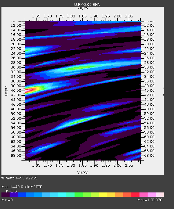
PMG Port Moresby, New Guinea - Earthquake Result Viewer

Earthquake location: Rat Islands, Aleutian Islands
Earthquake latitude/longitude: 51.3/178.0
Earthquake time(UTC): 2003/03/17 (076) 16:36:17 GMT
Earthquake Depth: 33 km
Earthquake Magnitude: 5.9 MB, 6.7 MS, 7.0 MW, 7.0 MW
Earthquake Catalog/Contributor: WHDF/NEIC
Network: IU Global Seismograph Network (GSN - IRIS/USGS)
Station: PMG Port Moresby, New Guinea
Lat/Lon: 9.41 S/147.15 E
Elevation: 67 m
Distance: 66.1 deg
Az: 213.589 deg
Baz: 20.622 deg
Ray Param: 0.05781668
Estimated Moho Depth: 40.0 km
Estimated Crust Vp/Vs: 1.60
Assumed Crust Vp: 6.122 km/s
Estimated Crust Vs: 3.826 km/s
Estimated Crust Poisson's Ratio: 0.18
Radial Match: 95.92265 %
Radial Bump: 400
Transverse Match: 82.32016 %
Transverse Bump: 400
SOD ConfigId: 4714
Insert Time: 2010-03-02 15:07:57.024 +0000
GWidth: 2.5
Max Bumps: 400
Tol: 0.001

Signal To Noise

ChannelStoNSTALTA
IU:PMG:00:BHN:20030317T16:46:30.007998Z2.5147422.1547208E-78.5683574E-8
IU:PMG:00:BHE:20030317T16:46:30.007998Z0.50245685.6625492E-81.1269724E-7
IU:PMG:00:BHZ:20030317T16:46:30.007998Z7.2481675.663862E-77.814199E-8
Arrivals
Ps4.1 SECOND
PpPs16 SECOND
PsPs/PpSs20 SECOND