You are here: Home > Network List > IU - Global Seismograph Network (GSN - IRIS/USGS) Stations List
> Station PMG Port Moresby, New Guinea > Earthquake Result Viewer
PMG Port Moresby, New Guinea - Earthquake Result Viewer
| Earthquake location: |
Ryukyu Islands, Japan |
| Earthquake latitude/longitude: |
27.9/130.3 |
| Earthquake time(UTC): |
1995/10/18 (291) 10:37:26 GMT |
| Earthquake Depth: |
27 km |
| Earthquake Magnitude: |
6.5 MB, 6.8 MS, 6.7 UNKNOWN, 7.1 MW |
| Earthquake Catalog/Contributor: |
WHDF/NEIC |
|
| Network: |
IU Global Seismograph Network (GSN - IRIS/USGS) |
| Station: |
PMG Port Moresby, New Guinea |
| Lat/Lon: |
9.41 S/147.15 E |
| Elevation: |
67 m |
|
| Distance: |
40.5 deg |
| Az: |
153.937 deg |
| Baz: |
336.795 deg |
| Ray Param: |
0.07430667 |
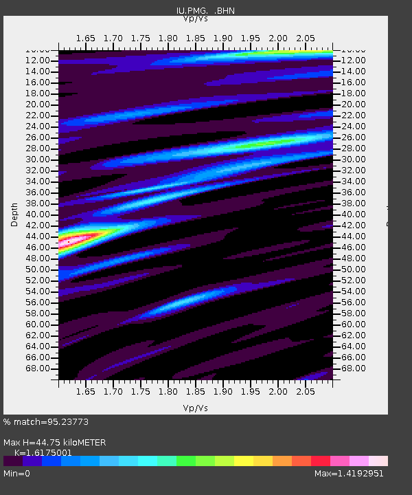
| Estimated Moho Depth: |
44.75 km |
| Estimated Crust Vp/Vs: |
1.62 |
| Assumed Crust Vp: |
6.122 km/s |
| Estimated Crust Vs: |
3.785 km/s |
| Estimated Crust Poisson's Ratio: |
0.19 |
|
| Radial Match: |
95.23773 % |
| Radial Bump: |
400 |
| Transverse Match: |
88.01101 % |
| Transverse Bump: |
400 |
| SOD ConfigId: |
4480 |
| Insert Time: |
2010-03-02 15:08:07.683 +0000 |
| GWidth: |
2.5 |
| Max Bumps: |
400 |
| Tol: |
0.001 |
|
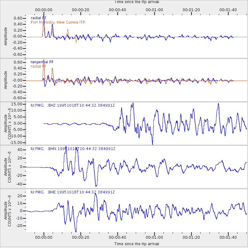
Signal To Noise
| Channel | StoN | STA | LTA |
| IU:PMG: :BHN:19951018T10:44:32.384991Z | 5.0774083 | 1.0786265E-6 | 2.1243643E-7 |
| IU:PMG: :BHE:19951018T10:44:32.384991Z | 1.5149231 | 5.532198E-7 | 3.651801E-7 |
| IU:PMG: :BHZ:19951018T10:44:32.384991Z | 1.1003428 | 4.4981678E-7 | 4.0879695E-7 |
| Arrivals |
| Ps | 4.8 SECOND |
| PpPs | 18 SECOND |
| PsPs/PpSs | 23 SECOND |


