You are here: Home > Network List > IU - Global Seismograph Network (GSN - IRIS/USGS) Stations List
> Station PMG Port Moresby, New Guinea > Earthquake Result Viewer
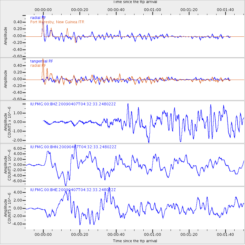
PMG Port Moresby, New Guinea - Earthquake Result Viewer

| Earthquake location: |
Kuril Islands |
| Earthquake latitude/longitude: |
46.0/151.5 |
| Earthquake time(UTC): |
2009/04/07 (097) 04:23:33 GMT |
| Earthquake Depth: |
31 km |
| Earthquake Magnitude: |
6.5 MB, 6.8 MS, 6.9 MW, 6.9 MW |
| Earthquake Catalog/Contributor: |
WHDF/NEIC |
|
| Network: |
IU Global Seismograph Network (GSN - IRIS/USGS) |
| Station: |
PMG Port Moresby, New Guinea |
| Lat/Lon: |
9.41 S/147.15 E |
| Elevation: |
67 m |
|
| Distance: |
55.3 deg |
| Az: |
185.273 deg |
| Baz: |
3.719 deg |
| Ray Param: |
0.06479982 |
| Estimated Moho Depth: |
21.0 km |
| Estimated Crust Vp/Vs: |
2.10 |
| Assumed Crust Vp: |
6.122 km/s |
| Estimated Crust Vs: |
2.919 km/s |
| Estimated Crust Poisson's Ratio: |
0.35 |
|
| Radial Match: |
96.007286 % |
| Radial Bump: |
400 |
| Transverse Match: |
77.86881 % |
| Transverse Bump: |
400 |
| SOD ConfigId: |
2760 |
| Insert Time: |
2010-03-02 15:08:09.209 +0000 |
| GWidth: |
2.5 |
| Max Bumps: |
400 |
| Tol: |
0.001 |
|
Signal To Noise
| Channel | StoN | STA | LTA |
| IU:PMG:00:BHN:20090407T04:32:33.248022Z | 19.72261 | 2.992969E-6 | 1.517532E-7 |
| IU:PMG:00:BHE:20090407T04:32:33.248022Z | 7.5650797 | 1.2756956E-6 | 1.686295E-7 |
| IU:PMG:00:BHZ:20090407T04:32:33.248022Z | 1.7404057 | 2.1754607E-7 | 1.2499733E-7 |
| Arrivals |
| Ps | 3.9 SECOND |
| PpPs | 10 SECOND |
| PsPs/PpSs | 14 SECOND |


