You are here: Home > Network List > TA - USArray Transportable Network (new EarthScope stations) Stations List
> Station I23K Minto, Yukon-Koyukuk, AK, USA > Earthquake Result Viewer
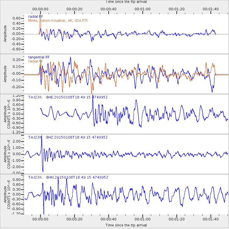
I23K Minto, Yukon-Koyukuk, AK, USA - Earthquake Result Viewer
*The percent match for this event was below the threshold and hence no stack was calculated.
| Earthquake location: |
Hokkaido, Japan Region |
| Earthquake latitude/longitude: |
43.7/144.9 |
| Earthquake time(UTC): |
2015/01/08 (008) 18:42:11 GMT |
| Earthquake Depth: |
131 km |
| Earthquake Magnitude: |
5.5 MB |
| Earthquake Catalog/Contributor: |
NEIC PDE/NEIC COMCAT |
|
| Network: |
TA USArray Transportable Network (new EarthScope stations) |
| Station: |
I23K Minto, Yukon-Koyukuk, AK, USA |
| Lat/Lon: |
65.15 N/149.36 W |
| Elevation: |
149 m |
|
| Distance: |
41.5 deg |
| Az: |
35.589 deg |
| Baz: |
271.79 deg |
| Ray Param: |
$rayparam |
*The percent match for this event was below the threshold and hence was not used in the summary stack. |
|
| Radial Match: |
58.11671 % |
| Radial Bump: |
384 |
| Transverse Match: |
57.821968 % |
| Transverse Bump: |
397 |
| SOD ConfigId: |
828811 |
| Insert Time: |
2015-01-22 19:21:34.596 +0000 |
| GWidth: |
2.5 |
| Max Bumps: |
400 |
| Tol: |
0.001 |
|
Signal To Noise
| Channel | StoN | STA | LTA |
| TA:I23K: :BHZ:20150108T18:49:15.474995Z | 4.9536633 | 1.1017336E-6 | 2.2240783E-7 |
| TA:I23K: :BHN:20150108T18:49:15.474995Z | 1.6854731 | 3.4195764E-7 | 2.0288527E-7 |
| TA:I23K: :BHE:20150108T18:49:15.474995Z | 2.437066 | 4.8118386E-7 | 1.9744392E-7 |
| Arrivals |
| Ps | |
| PpPs | |
| PsPs/PpSs | |


